The University of Massachusetts Dartmouth has announced that Professor of Computer Science and Associate Dean of the College of Engineering, Dr. Ramprasad Balasubramanian, has earned a $225,000 grant from the Office of Naval Research to address communication challenges of unmanned underwater vehicles (UUVs).
“For a team of vehicles to operate autonomously in a coordinated manner, robust communication is needed through a consistent exchange of messages,” said Dr. Balasubramanian. “The underwater environment presents many challenges for communication. When communication is unreliable or severely restricted we need to find other mechanisms by which a team can operate effectively.”
“The missions of these UUV teams are in many cases goal oriented. However, a particular goal of the team or even a single vehicle may change, requiring dynamic re-tasking in order to maintain the original mission, while accomplishing newly discovered tasks.”
Dynamic re-tasking will lead to vehicles abandoning their previous roles and assuming new ones. This may require vehicle or team of vehicles to break away from the pack. This is based on situational awareness in which a vehicle merges its own sensor data with the overall team knowledge.
“Situational awareness enables a vehicle to process and understand conclusions that it would not normally be able come to on its own,” said Dr. Balasubramanian. “This will allow UUVs to make changes to their current task in a more intelligent manner. But if the role reassignment is done in an ad hoc fashion the original mission could be severely compromised. ”
When one or more vehicles make changes to their task, task consensus needs to be reestablished. Task consensus is achieved when every vehicle in the team is aware of its own task as well as all other tasks of its team members.
This work is being performed in collaboration with researchers from the Naval Undersea Warfare Center (NUWC) at Newport, Rhode Island.
Modus Seabed Intervention Ltd., a provider of integrated subsea project services, has announced that it has taken delivery of a new 150hp HD ROV complete with Launch and Recovery System (LARS) from Schilling Robotics in Davis, California.
The 3,000m rated 150hp work-class ROV is a high performance vehicle and will be deployed by Modus across the range of its subsea operations in IRM (Inspection, Repair and Maintenance), survey, drilling and general construction support.
Jake Tompkins, Managing Director, Modus Seabed Intervention said “We are delighted to be working with Schilling and to continue our fleet development and investment program into specialist subsea technology with this leading edge HD ROV.”
Peter MacInnes, VP Sales & Marketing, FMC Technologies Schilling Robotics stated “The HD ROV has proven to be a rugged and highly capable system that is ideal for the varied operational markets supported by Modus. We are very pleased to have been awarded this contract and look forward to supporting Modus with their strategic focus and continued growth in the subsea industry”.
Thales has announced that it has been awarded the Maritime Mine Counter Measures (MMCM) contract by OCCAR, a defense equipment program management company, on behalf of the French Defence Procurement Agency (DGA) in France and UK MOD’s Defence Equipment & Support organisation. The contract will be undertaken in collaboration with BAE Systems and their partners in France (ECA Group) and in the UK (ASV, Wood & Douglas, SAAB). Initiated in 2012 under a cooperation agreement between France and the United Kingdom, the MMCM programme aims to develop a prototype autonomous system for detection and neutralisation of sea mines and underwater improvised explosive devices (UWIEDs).
The MMCM contract includes three stages, starting with a first phase for design. The next stages, which are subject to contract options, will manufacture and experiment the future mine countermeasures capabilities of both France (SLAM-F future mine countermeasures system) and the United Kingdom (MHC – Minecountermeasures and Hydrography Capability). The programme will deliver an autonomous, remotely operated mine countermeasures solution.
As part of the MMCM programme, Thales is committed to providing systems to both the French Navy and Royal Navy for two years of evaluation testing. Each system will comprise a USV (Unmanned Surface Vehicle) equipped with an autonomous navigation system, an obstacle detection and avoidance sonar, a threat identification and neutralisation capability based on ROVs (Remotely Operated Vehicles), a T-SAS (Towed Synthetic Aperture Sonar) and AUVs (Autonomous Underwater Vehicles). The geolocated AUVs will use the latest-generation synthetic aperture sonar SAMDIS with multi-aspect functionality for improved classification. They will perform their tasks autonomously with control from a host ship or shore-based station via high-data-rate communication links.
The systems, meeting the operational requirements of both nations, incorporate state-of-the-art technologies including very high-resolution multiview imaging sonars and sophisticated analysis tools to provide unparalleled levels of performance in automatic threat recognition and classification.
The project will be delivered by an integrated team including personnel from Thales in France and the UK as well as BAE Systems.
French and UK contractors involved in the MMCM system include ASV Ltd for the supply of the surface vehicle, ECA Group for the supply of the underwater unmanned vehicles, SAAB for the ROVs and Wood & Douglas for communications.
Thales will deliver the integrated Portable Operations Centre (POC) solution, which will incorporate command & control by Thales and BAE Systems. BAE Systems will provide the Mission Management System, managing the command and information systems, as well as the ROVs, the virtual visualization and experimentation suite.
The launch of this programme builds on the Lancaster House defence and security cooperation treaties signed in November 2010 and follows on from the Franco-British summit held on January 31st 2014.
“Thales has world-class expertise in mine countermeasures, having equipped more than half of the world’s in-service fleet of minehunters. We are proud to be part of this strategically important programme, which will provide France and the United Kingdom with key capabilities to support maritime security and the projection of amphibious forces,” said Patrice Caine, Chairman & Chief Executive Officer of Thales.
Osiris, a supplier of subsea engineering services, has announced that it has successfully completed a long-term project in which it carried out a wide range of tasks with cross-trained personnel on the 219MW wind farm, Humber Gateway, based 8km off the Holderness coast in East Yorkshire.
Osiris provided a Cougar-XT ROV to conduct seabed inspection work and transition piece cable pull-in teams. The teams mobilised from its shoreside support base in Grimsby using a moored, large multi-cat vessel and the ROV conducted around 30 dives in free swimming mode.
Aiden West, managing director of Osiris, praised the team work involved: “As our relationship with the client developed the scope of work evolved with it. The team put great emphasis on the quality of work produced and impressed the client with our internal standards and ability to provide efficient workable solutions”.
Osiris’ initial success led to an invitation to extend their role on the Humber Gateway and complete unfinished cable pull-ins through an externally positioned J-Tube. In supporting the project, Osiris was able to react quickly utilising its personnel already on-site, who were cross-trained to deliver a wide-range of offshore wind farm services, such as rigging, confined space rescue, confined space entry and cable pull-ins.
West continued: “Being able to mobilise on the door step of the Humber offshore renewable industry and utilise our assets on the East Coast had a significant impact on this project. Successful delivery of the Humber Gateway project has considerably raised Osiris’s profile within the region and we’ve developed a great relationship with one of the main industry leaders that should hopefully lead to more work.”
The joint development contract with JAMSTEC and Topy, a manufacturer of robot crawlers, will enhance the government agency’s ability to search deep underwater for natural resources using remotely operated vehicles (ROVs). Nissan’s AVM technology will help ROV operators avoid obstacles and navigate the ocean seafloor more easily.
The project exemplifies how AVM know-how is being put to practical use in complex operating environments and is among the Japanese Cabinet office’s Strategic Innovation Promotion Program (SIP), which aims to realize innovation through the promotion of research & development activities across government ministries.
AVM is one of the base technologies for Nissan’s autonomous drive vehicles, which the company aims to bring to market by 2020. First commercialized in 2007, AVM provides a virtual 360-degree overview of a car from a bird’s-eye view as pictured from above. The technology helps drivers visually confirm the vehicle’s position relative to parking spaces and adjacent objects and maneuver into parking spots more easily. Nissan added Moving Object Detection (MOD) technology to AVM in 2011 and continues to develop other associated safety technologies.
Under the Japanese government’s SIP initiative, JAMSTEC, Japan’s agency that develops next-generation technologies to explore for resources deep under the sea, and Topy Industries, one of the top manufacturers of robot crawlers in Japan, have teamed up to develop a highly-efficient operating system for undersea searches using remotely operated vehicles (ROVs). The ROVs being tested by JAMSTEC and Topy include a version of Nissan AVM which features three-dimensional picture processing capability.
The AVM 3D function is combined with the ROV’s camera to improve measurement of distances on the ocean floor. This provides operators, controlling the ROVs aboard mother ships at sea, an overhead real-time bird’s-eye view of the remote vehicle and its immediate surroundings. The goal is to improve the efficiency of undersea searches by avoiding obstacles on the seabed with better real-time situational awareness.
Scientists aboard NOAA Ship Okeanos Explorer have begun a series of 20 dives to investigate previously unseen depths of the Caribbean Sea and Atlantic Ocean – and the public can watch live video streaming online until 30th April.
Okeanos Explorer’s dual-body ROV system is loaded from the aftdeck of the ship into the water before conducting an exploration dive. (Credit: NOAA.)
During dives that are expected to go as deep as 3.7 miles, a sophisticated unmanned submarine (remotely operated vehicle), will broadcast live video from the seafloor, allowing anyone with Internet access to watch the expedition as it unfolds.
“We’ll be exploring an area of the United States Exclusive Economic Zone that science knows very little about,” said Alan Leonardi, Ph.D, director of NOAA’s Office of Ocean Exploration and Research, the federal program responsible for coordinating this expedition. “In order to understand and sustainably manage the ocean’s resources, we first have to survey what resources exist.”
Many of the expedition’s anticipated 20 ROV dives will take place in the Puerto Rico Trench, which is nearly 500 miles long and nearly 5.4 miles at its deepest – deeper than anywhere else in the Atlantic Ocean basin. Other areas to be explored include the Muertos Trough, Mona Channel and Virgin Islands Trough.
During the dives, Okeanos Explorer’s two-body ROV system will continuously capture high-definition video, which the ship will transmit to the Office of Ocean Exploration and Research’s website, www.oceanexplorer.noaa.gov, where anyone can follow along in near-real time.
“We don’t know exactly what we can expect to see,” said Lt. Brian Kennedy, the expedition’s coordinator and a member of NOAA’s Commissioned Officers Corps. “That’s precisely why we explore.”
But, he added, scientists do know a few things about the area: They know that it is tectonically active, with some seismic hazards such as earthquakes and tsunamis. They are also fairly certain the area contains deepwater snapper populations, deepwater corals and geological features such as seamounts and mud volcanoes.
Because of these characteristics, the area was identified by members of the ocean science community as important to explore, and data from the expedition will likely have long-lasting implications for scientists and resource managers in the Caribbean. As many as 40 scientists ashore are expected to participate remotely in the expedition.
Previous Okeanos Explorer expeditions have come across unknown species, recorded known animals exhibiting never-before-seen behaviors and sighted live animals previously only observed as lifeless specimens, Kennedy said.
This map shows the areas NOAA Ship Okeanos Explorer will explore during the 20 ROV dives to be conducted between April 10 and 30 in and around the Puerto Rico Trench and the U.S. Virgin Islands. Data displayed provided by ESRI, Delorme, GEBCO, USGS, NOAA NGDC, and other contributors; map created with ESRI ArcMap software. (Credit: NOAA.)
Okeanos Explorer, which is operated, managed and maintained by NOAA’s Office of Marine and Aviation Operations, has just spent about four weeks mapping more than 13,600 square miles of seafloor around the U.S. Virgin Islands and Puerto Rico. The maps show the seafloor in detail, making them useful for biologists, geologists, oceanographers and geophysicists. The expedition team also relied on these maps to determine where the ROV dives will take place.
During both its mapping and ROV expedition legs, the ship routinely collects data on seafloor depth, the makeup of the seafloor, and water temperature and chemistry.
But the facet of Okeanos Explorer expeditions that the public typically gets most excited about, Leonardi said, is its live-streamed ROV explorations. Live video from a 2013 expedition to deep-sea canyons off the northeast Atlantic coast of the U.S. garnered more than 875,000 views, he said.
“We have a lot of devoted fans who follow our explorations closely,” Leonardi said. “But with each expedition we reach new audiences who are fascinated by what we are seeing in the deep ocean. This public engagement improves science literacy and fosters an interest in the sciences among young people – perhaps leading to the next generation of ocean explorers.”
As part of the expedition, Kennedy and the two lead scientists aboard the ship will be leading a Reddit Ask Us Anything, or AUA, session on April 16, from 1:00 pm to 3:00 pm EDT. During this session, the public can pose their questions directly to the three experts, who also include Andrea Quattrini, Ph.D., a biologist with U.S. Geological Survey; and Mike Cheadle, Ph.D., a geologist with the University of Wyoming.
Bluefin Robotics has successfully delivered new vehicles to the United States Navy that will increase the Navy’s capability to remotely search and investigate ship hulls, harbor sea floors, and other underwater infrastructure for limpet mines, Improvised Explosive Devices (IEDs) and other objects of interest. The Navy accepted delivery of Bluefin Robotics’ ship hull inspection systems 4 and 5 under the “Explosive Ordnance Disposal, Hull Unmanned Underwater Vehicle Localization System” (EOD HULS) Program of Record, in February.
Each EOD HULS System (known as MK19), consists of two vehicles and associated support equipment. Bluefin’s third-generation Hovering Autonomous Underwater Vehicle (HAUV-3), used in the MK19 system, was developed under Office of Naval Research and the EOD Program Office (PMS 408). The vehicle allows detection of IEDs and limpet mines on ship hulls, piers, pilings, and quay walls for harbor and force protection.
“The MK19 vehicle operates by hull-relative navigation and control and provides very detailed acoustic images of a ship hull with 100 percent sonar coverage, without prior knowledge about the ship,” said Jerome Vaganay, Bluefin’s Director of Inspection Systems.
“Although it looks like a Remotely Operated Vehicle (ROV) with its six thrusters and its fiber optic data tether, the vehicle is powered by an onboard battery and operates primarily autonomously with the ability for the operator to take manual control to investigate contacts,” Vaganay said.
With the delivery of systems 4 and 5, the Navy currently owns 10 production vehicles and two prototypes. Another two systems are scheduled to be purchased by the Navy in 2015 under the EOD HULS contract, which is worth $15 million.
Kraken Sonar Inc., a manufacturer of Synthetic Aperture Sonar (SAS) technologies, has announced that its wholly-owned subsidiary, Kraken Sonar Systems Inc. has introduced AquaTrak™, a next generation Correlation Velocity Log. The product was launched at the Ocean Business conference in Southampton, United Kingdom.
Underwater navigation is essential for a diverse range of Unmanned Underwater Vehicle (UUV) military and commercial applications. Although GPS and other radio signals have been widely used for surface vessel navigation, these technologies are ineffective for underwater navigation because electromagnetic signals are blocked by seawater. Inertial sensing is a suitable and widely used technology for underwater navigation. However, position error tends to drift in the absence of input from aiding sensors. The most successful combination for underwater navigation has therefore been to combine inertial technology with velocity measurement using acoustic sensors that measure speed from echoes reflected off the seafloor.
The Doppler Velocity Log (DVL) has traditionally been the standard choice for integration into UUV navigation systems. Until now Correlation Velocity Logs (CVL) have not affected this domination of the marketplace because of the high level of signal processing required for correlating pairs of signals in CVLs. However, recent advances in low power electronics and advanced acoustic correlation signal processing techniques now enable CVLs to offer a superior price and performance value proposition over existing DVLs.
CVLs offer many advantages over DVLs, since they can achieve high accuracy at low velocities even during hover manoeuvres. DVLs use narrow beam widths, while CVL transmitters have wide beam widths. This gives CVLs the potential to use lower frequencies thus permitting operation in deeper water; increased accuracy; reduced power requirements for the same depth and smaller form factors.
Kraken’s AquaTrak™ Correlation Velocity Log provides both long range navigation and high resolution accuracy. The highly flexible and modular design allows the unit to be used in a standalone configuration or as part of an Integrated Navigation System.
A CVL measures a two-dimensional displacement vector between two receiver channels for successive pulses, so that the corresponding velocity measurement is generated by the displacement divided by the time interval between pulses, with no need for a speed of sound measurement.
AquaTrak’s piezocomposite transducers operate at 150 kHz enabling altitudes of 300m above the seabed. This operating frequency was selected as an ideal compromise between a deeper propagation of the acoustic pulses (due to the reduction in attenuation with decreasing frequency) while avoiding background noise at lower frequencies. The acoustic power requirements have also been minimized for UUV integration and operation — particularly for autonomous underwater vehicles.
To ensure that the incoming signals used within the correlation calculation result from bottom reflection rather than volume reverberation or background noise, AquaTrak uses advanced Synthetic Aperture Sonar acoustic correlation signal processing techniques. It first determines the height of the instrument above the seabed and uses time of flight calculations to neglect signals detected before this depth threshold.
The unit can therefore operate as an altimeter to verify other onboard instrumentation. The transmitted power is then automatically adjusted to take into account the attenuation of the returns from the seabed caused by transmission and absorption losses by the seafloor. The complex form of the correlation coefficient between two complex acoustic signals is then used by AquaTrak to generate velocity measurements.
The breakthrough in Kraken`s AquaTrak™ CVL was understanding how to use the SAS transducer arrays as a CVL in order to estimate with sufficiently high accuracy the three-dimensional velocity vector, giving the displacement between successive pings. The side-by-side comparison (shown below) of the forward ground speed given by a 300 kHz SAS used as a CVL and a conventional 600kHz DVL shows the much greater accuracy achieved by the CVL, which provides the evidence of the high potential of CVL technology.
Karl Kenny, Kraken’s President and CEO said, “AquaTrak is the outcome of a three year product development effort to design and build next generation velocity sensors for underwater navigation. AquaTrak has been developed using a combination of computer modelling, simulation and a comprehensive sea trials program. While DVLs have traditionally been the instrument of choice for interfacing with AUV navigation systems, we expect that to change in the very near future. The worldwide acoustic velocity sensor market represents an annual multi-million dollar revenue opportunity for Kraken.”
Fugro, a provider of subsea, geotechnical and geosciences services, has announced that two of the firm’s vessels, currently searching the southern Indian Ocean for the missing Malaysia Airlines flight MH370, were involved in the discovery of a previously uncharted shipwreck at a depth of around 3,900 metres.
The wreck is likely to be that of a 19th century merchant sailing ship, and so great is the detail that what is believed to be scattered coal can be seen throughout the debris, which may indicate that it had an auxiliary steam-powered engine. The debris also appears to include an anchor and the imagery will be provided to expert marine archaeologists for possible identification.
“It’s a fascinating find,” said the Australian Transport Safety Bureau’s (ATSB) Peter Foley, Director of the Operational Search for MH370, “but it’s not what we’re looking for. Obviously, we’re disappointed that it wasn’t the aircraft, but we were always realistic about the likelihood. And this event has really demonstrated that the systems, people and the equipment involved in the search are working well. It’s shown that if there’s a debris field in the search area, we’ll find it.”
When the deep tow system operated by Fugro Equator detected a cluster of small sonar contacts in the southern part of the search area, 12 nautical miles to the east of the 7th arc, the sonar data was carefully analysed. It was categorised as Class 2 – ‘of potential interest but unlikely to be related to MH370’.
“It could not, however be ruled out,” said Peter Foley. “There were characteristics of the contact that made it unlikely to be MH370, but there were also aspects that generated interest, multiple small bright reflections in a relatively small area of otherwise featureless seabed.”
All sonar data collected by Fugro goes through a detailed analysis and an exhaustive review process to ascertain its quality, coverage and most importantly any sonar contacts of interest. “The analysis starts with the mission crew on board the search vessels,” continued Peter. “The data is then reviewed again ashore by sonar analysts at Fugro’s office in Perth and then it is independently reviewed by the sonar experts in the ATSB’s Operational Search team. The process is methodical, meticulous and it is designed to ensure that nothing is missed. In this case we planned to resurvey the contact in more detail.”
The Fugro Supporter was tasked to further investigate the contact, performing a high resolution sonar scan using Fugro’s Echo Surveyor VII autonomous underwater vehicle (AUV). The high resolution data revealed a large number of sonar contacts lying very close to the seafloor, at a depth of around 3,900 metres. The majority of the contacts were comparatively small – around the size of a cricket ball – interspersed with a few larger items, the biggest being approximately 6 metres in its longest dimension. Although the debris field appeared to be of man-made origin it did not exhibit all the characteristics of a typical aircraft debris field.
An additional AUV low-altitude mission was then undertaken using the underwater camera to gather images of the field. Analysis of the images revealed that the debris was actually the wreck of a ship.
Fugro’s search director Paul Kennedy of Fugro Survey explained: “This find has given us a great deal of confidence. It shows we are able to find small pieces of metal on the seafloor, a long way down. Pieces from MH370 would be roughly 10 times as big as those of the wrecked ship.”
Hydroid, Inc., a subsidiary of Kongsberg Maritime and a manufacturer of autonomous underwater vehicles (AUVs), has announced that it will be running five open enrollment training courses during 2015. The courses will provide participants with operation, maintenance, troubleshooting and navigation skills for REMUS vehicles. All courses are led by Hydroid’s expert technicians, and will be held at the company’s new manufacturing facility, located in Pocasset, Massachusetts.
The course descriptions are as follows:
REMUS 100 Field Maintenance Course: This five-day course is designed to provide REMUS 100 operators with a more detailed view of maintenance procedures and troubleshooting techniques for both onboard maintenance and daily routines. Students who successfully complete course requirements will receive a Field Maintenance Certificate.
REMUS 100 Operators Course: This introductory five-day program is designed to provide a limited number of attendees with a thorough understanding and hands-on operational experiences required to successfully operate and maintain the REMUS system.
NAV-P Course: This two-day course is designed for operators that require a greater understanding of the navigation component and accuracies within the vehicle, how it relates to the data collected, and practical guidance on improving and monitoring those accuracies.
NAV-Lab Course: This course is designed for NavLab users and focuses on the analysis of post processing data from practical exercises to consolidate information learned in the Nav-P Course.
Side Scan Sonar Data Interpretation Course: This two-day course will focus on sonar operational theory and data interpretation for overall survey, as well as targeted search operations and mapping applications. It will be presented jointly with John Perry Fish, founder of American Underwater Search and Survey.
The National Oceanography Centre (NOC) has announced that it has joined with 18 other partners to develop Europe’s first ultra-deep-sea robot glider. This glider will be capable of sampling the ocean autonomously at depths of 5000m, and possibly at greater depths in the future, for up to three months at a time. This project has won €8M of funding from the European Union’s Horizon2020 programme to develop and test this innovative new technology.
The capability of this new glider to reach at least 75% of the ocean will open up new possibilities for science and industry. These include monitoring submarine biodiversity and conducting environmental impact assessments for potential sea bed mining and exploration.
For example, the new glider will be able to detect the of presence of ‘plumes’ of sediment created by mining processes by using novel sensors developed by the NOC and housed in the ‘nose’ of the glider. These plumes are an important element of the submarine ecosystem.
Dr Mario Brito, who is leading the project from the NOC, said “The development and integration of sensors that can work at these depths will be a real challenge…it is something that has not been done before and so the science behind it is really innovative. Furthermore the range of sensors this glider can carry makes it well suited to a wide range of applications, both within research and industry.”
In addition the NOC will also be responsible for the development of pressure tolerant structures within glider, its propulsion system, and testing it at sea. The final test is due to take place in September of 2019 off South East Ireland. NOC will use advanced ‘risk and reliability’ techniques to accurately quantify the risk of the glider failing under particular conditions.
“This glider will be designed to meet a well constrained reliability target, which will really help to ensure successful operations in the future” added Dr Brito.
Funding for this project came from the European Union Horizon 2020 programme on “Unlocking the potential of seas and oceans”. This four year project, called BRIDGES, sees the NOC work closely with nine SME’s from the UK and Europe.
Kevin Forshaw, Director of Enterprise and Research Impact at the NOC said “The NOC is really pleased to have the opportunity to work so closely with so many SMEs, and to use the world class expertise here to help them grow and produce a European first in submarine glider technology.”
Pierre Bahurel who is the general manager of the French ocean forecasting centre, MERCATOR OCEAN, observed that “Glider technology has proven to be one of most promising ocean observing techniques. Deep gliders have a strong role to play in operational oceanography, as well as enhancing our knowledge of the oceans.”
ADLINK Technology, a provider of cloud-based services and embedded systems, has announced its sponsorship of the Cornell University Autonomous Underwater Vehicle (CUAUV) team’s entry into the 18th Annual International RoboSub competition, held at the Space and Naval Warfare Command Research facility in San Diego, CA.
“We compete against teams from across the world, and have won first place five times in the past six years. A significant contribution to our success has been the ADLINK-sponsored computer, which we used on our main vehicle for last year’s competition and are using again in this year’s design,” said Jonathan Chan, CUAUV simulation project leader.
CUAUV’s vehicle, Argo, is powered by ADLINK’s Express-HL COM Express computer-on-module, featuring a 4th generation quad-core Intel Core i7 processor with Mobile Intel QM87 Express chipset. The Express-HL acts as the lone on-board computer and handles complex and essential tasks, including integrating data from sensors such as sonar, a Doppler Velocity Log, hydrophones, and on-board cameras. In addition, the Express-HL module and carrier board run the computer vision code and mission logic that make it possible for Argo to be autonomous.
“Based on the performance of our existing computer, we are in the process of configuring a new module, also sponsored by ADLINK, to serve as the backbone of the to-be-completed autonomous cooperative mini-sub, and additionally to serve as a replacement for the main computer, if necessary,” says Zander Bolgar, CUAUV mission framework architect.
The CUAUV team, made up of 41 students from two of Cornell’s colleges and from six different majors, has placed top ten in the RoboSub competition every year. Development of the autonomous underwater vehicle is a year-long process, with the team spending more than 20,000 person-hours designing its vehicle.
“ADLINK is pleased that the Cornell team had a good experience with our module last year and has chosen to depend on it again to help them get another win,” said Elizabeth Campbell, general manager of ADLINK Americas. “This is a dedicated group of individuals with whom we are proud to be associated.”
ADLINK’s Express-HL is a COM Express COM.0 R2.1 Basic Size Type 6 module supporting the 64-bit 4th Generation Intel Core i7/i5/i3 or Celeron processor with CPU, memory controller, and graphics processor on the same chip, and is specifically designed for customers who need high-level processing and graphics performance in a long product-life solution. The Express-HL supports Intel Hyper-Threading Technology (up to 4 cores, 8 threads) and DDR3 dual-channel memory at 1333/1600 MHz to provide excellent overall performance. Intel Flexible Display Interface and Direct Media Interface (DMI) provide high-speed connectivity to the Intel QM77or HM86 Express chipset.
The international RoboSub competition is co-sponsored by the Association for Unmanned Vehicle Systems International (AUVSI) Foundation and the U.S. Office of Naval Research (ONR) with the goal of advancing the development of AUVs. The event serves to foster ties between young engineers and organizations developing AUV technologies. The competition mission elements and tasks are designed to simulate real-world challenges, such as visual recognition of objects, navigation, and acoustic sensing.
The NATO Centre for Maritime Research and Experimentation (CMRE) has announced that it has successfully demonstrated the use of unmanned systems for maritime surveillance, as part of the PERSEUS FP7 project. The PERSEUS project (Protection of European BoRders and Seas through the IntElligent Use of Surveillance) is coordinated by Spanish technological company Indra, and is a flagship R&D project in the maritime security segment within the European Commission.
Conventional surveillance technologies cannot easily detect fast boats, which generally have small radar signatures and do not carry automatic identification systems (AIS), and this was the impetus for the undertaking of the project by CMRE and its partners.
During the project, CMRE scientists and engineers worked to design, develop and demonstrate at sea concepts of continuous, real-time passive underwater acoustic systems for maritime surveillance. The objectives were successfully met by using innovative solutions integrated on board unmanned mobile platforms, both on an underwater glider (an autonomous underwater vehicle which uses shifts in mass to steer and changes in buoyancy to dive and surface) and a Wave Glider (an autonomous vehicle with a surface float and a submerged glider, generating forward movement by exploiting sea wave energy).
The embedded cutting-edge passive sonar surveillance system proved to be particularly effective due to its real-time continuous monitoring capability and the availability of several functionalities ranging from detection and localization to vessel classification. Furthermore, the platform/system combination has proven to be persistent and covert with wide area coverage and minimum environmental impact. Real-time detections and localizations have been made both on board the underwater glider and the Wave Glider, and the detection/tracking results have been disseminated to both CMRE and national control centers for display and further analysis.
Target classification algorithms were also applied successfully in near real-time during at-sea demonstrations. Adaptation of the Wave Glider for shallow coastal waters was tested by adding low-cost add-ons for above-water sensing, in the form of inexpensive daylight and thermal cameras, and radar detection devices. This technology may help to enable the detection of anomalous behaviours of marine traffic by fusing above-water and underwater imagery.
The CMRE claims to have been the first to demonstrate a complete system for underwater acoustic surveillance with mobile robots. In the future, these systems could be used within a network to continuously monitor maritime areas of interest.
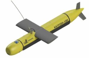
Kraken Sonar Inc., a developer of Synthetic Aperture Sonar (SAS) technology, has announced the development of KATFISH (Kraken Active Tow FISH), a sonar platform for military and commercial applications.
The primary objective of the KATFISH project is to develop an actively controlled, intelligent towfish as a platform for real-time ultra-high resolution seabed mapping system, based on Kraken’s Miniature Interferometric Synthetic Aperture Sonar (MINSAS) technology and Real-Time SAS Processing algorithms.
The KATFISH system is comprised of an actively controlled smart towfish, winch and handling subsystem and operator console. The winch and handling subsystem provides the capability to launch, tow, recover and stow the tow fish. The entire system is designed to be quickly installed and removed from craft of opportunity platforms and is packaged for easy transportation.
Conventional side scan systems are limited in that they only provide high resolution imagery at short range. KATFISH produces ultra-high resolution seabed imagery with constant resolution to full range. The additional information provided by KATFISH delivers a detection and classification capability that cannot be achieved with a conventional sidescan sonar.
KATFISH also generates highly accurate bathymetry data that is co-registered and geo-referenced to the same pixel grid co-ordinates as the imagery. Operators can produce crisp seabed imagery and detailed 3D digital terrain maps of seafloor topography that exceed IHO SP-44 survey standards.
The capability of generating centimeter-scale resolution in 3D also provides significant performance improvements in the detection, classification and identification of small seabed objects.
The KATFISH system also implements an innovative SAS gap filler transmitter that produces high resolution data in the nadir region. The system uses two rows of identical receiver elements to deliver bathymetry. An additional lower frequency transmit element, unique to KATFISH, provides a SAS resolution gap fill directly under the platform.
Sonar data is transferred from the transceiver to the processing unit via a Gigabit Ethernet network interface. The sonar operation is controlled from a graphical user interface (GUI) on a notebook computer. The operator sets the sonar parameters in the sonar control window, while depth, imagery and other sensor data are captured and displayed by Kraken’s INSIGHT application software.
KATFISH is currently under development and has successfully completed proof-of-concept sea trials. The system is now being commercialized with a series of planned technical milestones.
RE2, Inc., a developer of mobile manipulation systems, has announced that the company has been awarded a $2.7 Million contract by the Office of Naval Research to develop an Underwater Dexterous Manipulation System for Explosive Ordnance Disposal (EOD) Applications (DMEA). RE2’s DMEA technology will provide EOD personnel with the ability to remotely and effectively address Waterborne Improvised Explosive Devices (WIEDs).
“We are honored that ONR chose RE2 to develop a strong, highly dexterous underwater manipulation system,” stated Jorgen Pedersen, president and CEO of RE2. “We thrive on complex engineering challenges and are excited to leverage our mobile manipulation expertise for the underwater systems market.”
WIEDs pose a significant potential threat to vessels, bridges, and ports. WIEDs placed in congested areas, such as bridge pilings, are particularly difficult to access and defeat. RE2’s dual-arm dexterous manipulation technology integrated onto an Unmanned Underwater Vehicle (UUV) will make it possible to perform EOD tasks in confined spaces.
Pedersen continued, “We are working with several unmanned underwater systems subject matter experts, including Bluefin Robotics, The Pennsylvania State University Applied Research Lab, SPAWAR Systems Center Pacific, and Dr. Hagen Schempf, to ensure the success of the technology and program.”
The Navy uses UUVs for many types of missions, including the location and identification of underwater threats such as mines, ocean floor mapping, and optimizing remote sensing platforms. The ability to use wireless technology to charge UUV batteries while underwater may significantly decrease time between missions, improving overall utility.
“Underwater data and energy transfer are expected to multiply the effectiveness of Navy-operated UUVs and other unmanned platforms by providing a vehicle-agnostic method for autonomous underwater energy charging,” said Alex Askari, Naval Surface Warfare Center, Carderock Division (NSWCCD) technical lead. This technology can be used on many different types of vehicles.
NSWCCD supported Naval Undersea Warfare Center, Division Newport (NUWC DIVNPT) in demonstrating this capability during the first-ever Naval Technology Exercise (ANTX), Aug. 10-14 at the Stillwater Basin Test facility in Newport, Rhode Island. ANTX is a weeklong showcase of Undersea Constellation technology from NUWC DIVNPT, and Space and Naval Warfare Systems Command SPAWAR Systems Center Pacific (SSC PAC).
NSWCCD previously executed a successful underwater wireless energy transfer demonstration in a 6,000 gallon tank at its West Bethesda, Maryland facility, June 29-July 3.
These concepts of wireless underwater energy transfer, such as Forward Deployed Energy and Forward Deployed Energy and Communications Outpost (FDECO), were born in NSWCCD’s Disruptive Technologies Lab.
“We want to recharge a battery underwater through wireless technology, and we want to know the batteries charge to the highest fidelity,” Mayer Nelson, NSWCCD technical project manager said. The NSWCCD demonstration was a collaborative effort as Carderock hosted teams from NUWC DIVNPT and SSC PAC.
“The NUWC team was on-hand to simulate the full capabilities of the NUWC-developed Mid-sized Autonomous Research Vehicle (MARV) UUV, as well as to provide assistance with testing,” Joseph Curran, NSWCCD integration lead said.
The MARV is 16.5 feet long and just slightly more than one foot in diameter for testing different UUV programs and technologies.
Carderock Division’s developed technology enables power transmission between underwater systems, such as UUVs. During the main demonstration on July 3, the team was successful in transferring power wirelessly from an underwater docking station to a MARV UUV section, and ultimately to the UUV’s battery, which was charged at 2 kilowatts while submerged, according to Nelson.
A battery State of Charge (SOC) program developed by Dr. Michael Knauff, a Naval Ship Systems Engineering Station (NAVSSES) in Philadelphia electrical engineer was integrated by Crystal Lutkenhouse, a NSWCCD mechanical engineer.
“We tested a Carderock-developed algorithm and pulled in data from the actual battery; then ran voltage, current and temperature data through the data acquisition system,” Knauff said.
During underwater energy transfer, this program was run using data that had been transferred wirelessly underwater using SSC PAC’s underwater optical communications system and allowed an enhanced estimation of the charge on the battery through the SOC program.
The National Oceanography Centre (NOC) has begun the latest in a series of ambitious marine robotic vehicle trials off the UK coast. Working in partnership with the World Wildlife Fund (WWF), NOC has deployed a submarine glider and an autonomous surface vehicle into the Celtic Deep area of the Celtic Sea – the two long-endurance robotic vehicles will now work together over the next three weeks to investigate why this area is particularly attractive to marine predators such as dolphins and seabirds. The project will pave the way for a new era in marine research.
ASVs C-Enduro, an unmanned surface vehicle (USV) known as ‘Thomas’, is part powered by wind and solar energy and controlled remotely by satellite. Thomas will work in tandem with an underwater Slocum Glider moving up and down in the water.
Each vehicle will be carrying sensors capable of measuring the temperature and salinity of the water, and acoustic ‘pingers’ to detect plankton and fish shoals. The surface vehicle will also carries GoPro cameras to capture images of marine life and litter, and acoustic monitors to detect clicks and whistles from echo locating marine mammals.
The information will give scientists a better understanding of the environment, helping inform conservation and management of marine activities.
The C-Enduro will transit to an area South West of the Welsh coast known as the ‘Celtic Deep’, approximately 50 miles offshore. The glider was launched from Royal Research Ship Discovery and was ‘flown’ to meet Thomas at a point off the Welsh coast.
Next month the vehicles are scheduled to return to the National Oceanography Centre laden with pictures and data, which are expected to reveal the extraordinary richness of these waters.
The ‘Celtic Deep’ is a hotspot for marine mammals, including common dolphins, harbour porpoises and the world’s second biggest animal, the fin whale. Despite this it has yet to be designated as a Marine Conservation Zone (a type of marine protected area in the UK). The data gathered by Thomas could help inform the Welsh and UK Government processes for protecting this unique region.
The vessel is named Thomas after the father of Roland J Rogers of the National Oceanography Centre, the latest of five generations of seafarers.
Dr Lyndsey Dodds, Head of Marine Policy at WWF-UK, said: “As well as being home to a wonderful array of animals and plants, our seas provide vital resources such as food and energy. But our oceans are under increasing pressure and are in need of greater protection. By using innovative technology like these vehicles we can learn more about the life that is offshore and out of our sight and make sure these areas are given the protection that they need.”
NOC’s Prof Russell Wynn, who is co-ordinating the research for WWF, said: “Marine robotic technologies give us the opportunity to have a persistent presence in the ocean, and are changing the way in which we conduct science in the marine environment. The two vehicles on this mission are bristling with novel sensors that will act as our eyes and ears in the water, observing and detecting seabirds and marine mammals. The vehicles will also be continuously collecting data about weather conditions at the sea surface, the temperature and salinity of the water column, and the distribution and abundance of plankton and fish prey.”
Lack of data about the marine environment can present problems to policy-makers involved in marine conservation and management, such as designation of Marine Protected Areas. Autonomous vehicles or ‘robots’ have a huge potential as a solution to this problem, as they present a relatively low-cost alternative to large research ships as a means of gathering data. In the long term, developing countries in particular could scale up the use of these vessels to carry out marine monitoring in some of the least-studied areas of the ocean, enabling them to develop more effective conservation and management plans.
The US Naval Sea Systems Command has announced that it has received a risk-reduction decision approval, known as a Milestone A decision, for the Large Displacement Unmanned Underwater Vehicle (LDUUV) program. Milestone A approval grants the program the authority to move into the next phase of development, which will allow the Navy to commit resources to mature technology and reduce risks prior to production and fielding.
The LDUUV is a new class of large-displacement unmanned undersea vehicles that will provide increased endurance, range and payload capabilities. The system is being designed for intelligence, surveillance and mine countermeasure missions, and is based on a modular, open architecture that will allow the Navy to incrementally develop new mission sets for the craft.
LDUUV will be capable of being stowed, launched and recovered by multiple-host platforms, including littoral combat ships, Virginia-class submarines and Ohio-class guided-missile submarines. The craft is being developed by the Unmanned Maritime Systems Program Office, which is part of the Program Executive Office Littoral Combat Ships (PEO LCS).
Following the successful Milestone A decision, a draft LDUUV request-for-proposals has been released on the Federal Business Opportunities website.
PEO LCS is affiliated with Naval Sea Systems Command, and provides a single program executive responsible for acquiring and sustaining mission capabilities of the littoral combat ship class, beginning with procurement and ending with fleet employment and sustainment. The combined capability of LCS and LCS mission systems is designed to dominate the littoral battle space and provide U.S. forces with assured access to coastal areas.
Australia’s Queensland University of Technology (QUT) has announced that it has developed the world’s first autonomous robot designed to seek out and kill the crown-of-thorns starfish (COTS), which are devouring the world’s coral reefs.
Conceived by QUT doctors Matthew Dunbabin and Feras Dayoub, the COTSBot drone patrols just a foot or two off the seafloor and is outfitted with stereoscopic cameras to give it depth perception. It is also equipped with five thrusters to maintain stability, and a GPS system. The drone is designed to patrol for up to eight hours, and when it encounters its target, the COTSBot injects it with a fatal dose of bile salts using a syringe. The robot can deliver more than 200 lethal shots of bile, which are harmless to everything else on the reef.
“Human divers are doing an incredible job of eradicating this starfish from targeted sites, but there just aren’t enough divers to cover all the COTS hotspots across the Great Barrier Reef,” Dr. Dunbabin said in a statement. “We see the COTSBot as a first responder for ongoing eradication programs – deployed to eliminate the bulk of COTS in any area, with divers following a few days later to hit the remaining ones.”
Due to overfishing of the marine life that eats them, the COTS population has exploded recently and allowed the starfish to feast on the world’s coral reefs. Research suggests that COTS are responsible for about 40 percent of the Great Barrier Reef’s coral loss.
One feature of the COTSBot that separates it from other drones is its ability to learn. The robot has been trained to identify COTS by using thousands of images of COTS collected on the reef. If is unsure about whether something is actually a COTS, it will take a photo of the object rather than injecting it. The photo will then be examined by a human and the feedback will be incorporated into the robot’s memory.
The COTSBot has already completed its first sea trials in Queensland’s Moreton Bay to test its mechanical parts and navigation system, and is shortly expected to begin working the reef autonomously.
Boston Engineering, an engineering consultancy firm, has announced that it has been awarded a $500,000 START Stage III grant from venture capital firm MassVentures to accelerate the commercialization of its BIOSwimmer unmanned underwater vehicle (UUV) and related autonomous technology. START is a $3 million annual state initiative administered by MassVentures to help growing Massachusetts-based companies commercialize technologies developed under Small Business Innovation Research (SBIR) and Small Business Technology Transfer (STTR) contracts.
“MassVentures has been a trusted partner throughout the development of our game-changing underwater robotics, and we appreciate the continued support,” said Mark Smithers, co-founder and chief technology officer of Boston Engineering. “The START program reflects the commonwealth’s commitment to fostering new opportunities for businesses and its skilled workforce.”
The BIOSwimmer is a biologically-inspired UUV that replicates the dynamics of a biological fish to move rapidly and accurately – and to operate in areas inaccessible by other vehicles. The highly maneuverable UUV performs operations that include inspecting ships, securing ports, and conducting infrastructure searches more rapidly, more accurately, and in more challenging areas than other underwater solutions.
“Our vehicle solutions are addressing the need to keep people working in maritime environments out of harm’s way and to enhance underwater security, research, maintenance, and other applications,” said Michael Rufo, director of Boston Engineering’s Advanced Systems Group. “The START grant provides us with a unique opportunity to bring our UUV technology forward into homeland security, oil & gas, and other significant markets.”