Quantcast
Channel: UUV News | Autonomous & Unmanned Underwater Vehicles | ROV News
Viewing all 689 articles
Browse latest View live

Real Time Synthetic Aperture Sonar Deployed on US Navy AUV

$
0
0


Kraken's AquaPix® Real Time Miniature Synthetic Aperture Sonar integrated onboard a REMUS 600 AUV

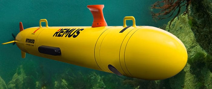
Kraken’s AquaPix® Real Time Miniature Synthetic Aperture Sonar integrated onboard a REMUS 600 AUV

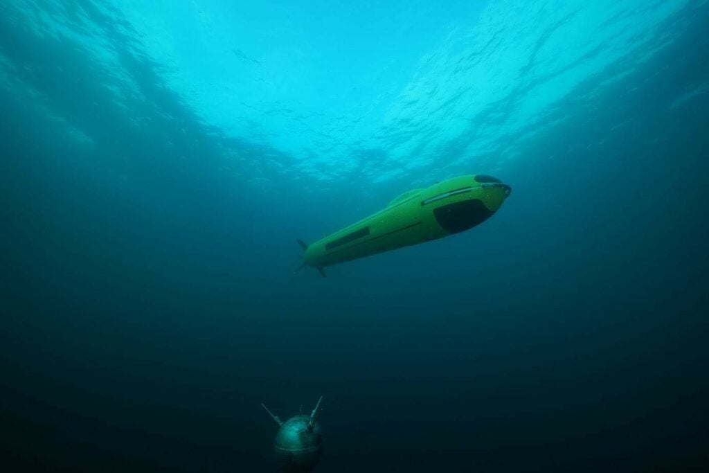
Kraken Robotic Systems Inc., a wholly-owned subsidiary of Kraken Robotics Inc., has completed development of a real-time Synthetic Aperture Sonar (“SAS”) system that has been successfully integrated and tested onboard a US Navy REMUS 600 Autonomous Underwater Vehicle (AUV) operated by the Naval Undersea Warfare Center in Rhode Island.

“Kraken is proud to have developed an AUV solution for real-time, ultra high-resolution imaging and 3D mapping of the seafloor,” said Karl Kenny, Kraken’s President and CEO.

“We expect this technology will revolutionize the way in which big data from Synthetic Aperture Sonar imagery and bathymetry is processed. We would like to extend our thanks and appreciation to our colleagues at the Naval Undersea Warfare Center for their support in deployment and testing of our solution on their REMUS 600 AUV.”

The AquaPix® MINSAS Synthetic Aperture Sonar features real-time processing; this allows for the creation of detailed acoustic images which can be analysed on-the-fly by the AUV’s onboard computers to enable the vehicle to make enhanced decisions on the best way to continue the mission. This acquisition and processing of high resolution raw data can increase the speed and accuracy of maritime missions – particularly autonomous AUV minehunting where large search areas must be covered in high tempo.

Mr. Kenny went on to say, “The major concern of mine countermeasures is to keep sailors far away from the mine threat while having a high level of confidence in the detection and classification of possible threats. Real-time SAS signal processing onboard an AUV is a significant step forward from the current approach. Kraken’s real-time SAS can increase safety, improve operational efficiency, reduce the mission risk of missing mines and significantly reduce and/or eliminate post mission analysis time.”

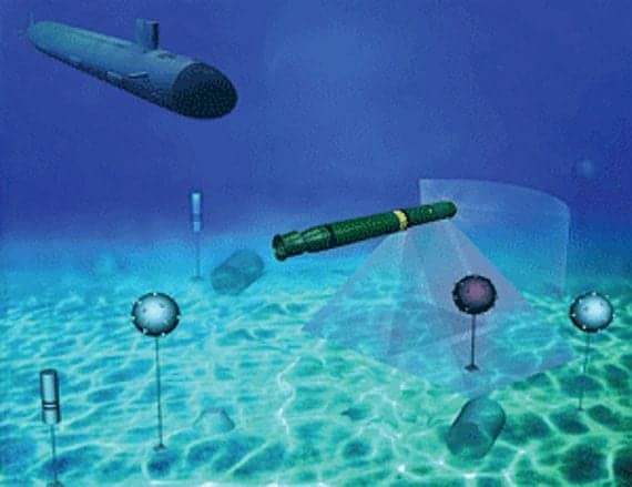
USING KRAKEN SAS TECHNOLOGY FOR MINEHUNTING

At least 5cm of target pixel resolution is required for effective minehunting. This can be achieved with Synthetic Aperture Sonar (SAS) to ranges of over 250 metres. While conventional side scan sonars can also achieve this resolution, they can only do so at very short range, typically limited to less than 25 metres. This range limitation has a direct effect on search times and results in very inefficient area coverage rates.

Synthetic Aperture Sonar can provide up to 10 times the range and area coverage rates of conventional side scan sonar. SAS is particularly well suited for AUVs and industry experts predict that SAS will replace conventional side scan sonars for many military applications. SAS technology also has significant potential in other underwater imaging applications including offshore energy, seabed surveying, marine archaeology, debris mapping and search and salvage operations.


The post Real Time Synthetic Aperture Sonar Deployed on US Navy AUV appeared first on Unmanned Systems Technology.


Teledyne Gavia Releases New AUV Navigation Module

$
0
0

Teledyne Gavia AUV navigation module

Teledyne Gavia, a manufacturer of Autonomous Underwater Vehicles (AUVs) and related systems, has announced the release of a new navigation module that incorporates iXblue‘s new Phins Compact C3 with a Teledyne RDI 1200 kHz Workhorse DVL (Doppler Velocity Log).

Teledyne’s Gavia AUV can be utilized in various applications, including geophysical surveys, cable and pipeline surveys, environmental surveys, and under ice surveys, as well as Mine Countermeasures (MCM), Rapid Environmental Assessment (REA), and Intelligence, Surveillance, and Reconnaissance (ISR) surveys.

Equipping the Gavia with the Phins Compact C3 and TRDI‘s Workhorse DVL offers a 0.3% CEP50 Distance Travelled navigation accuracy in a very compact module that lowers the weight and size of the vehicle from previous navigation options. The Phins Compact C3 is the second inertial navigation system from iXblue that Teledyne Gavia has integrated into the Gavia AUV. Teledyne Gavia has had great success with the iXblue C5, leading to the extension of the portfolio of iXblue technology available on the Offshore Surveyor with the introduction of the Phins Compact C3.

The post Teledyne Gavia Releases New AUV Navigation Module appeared first on Unmanned Systems Technology.

Saab Provides Sabertooth AUV/ROV for Oil & Gas Inspection

$
0
0

Saab Sabertooth AUV ROV

Saab has announced that is has signed a contract to provide a customer in the oil and gas industry with the Sabertooth Autonomous Underwater Vehicle/Remotely Operated Vehicle (AUV/ROV). The customer has ordered the first vehicles in a planned fleet of Sabertooth vehicles. Under the agreement, Saab and the customer will work together to further develop this vehicle and its applications in the field of subsea Inspection, Maintenance and Repair (IMR), survey and intervention work.

“We are pleased to have received this order for an initial number of systems. For us it is definitely a break-through to win a Sabertooth order from a leading company operating within the Oil & Gas domain. We will work closely together with the customer as they implement the system and we look forward to supporting them with their strategic focus and continued growth,” says Görgen Johansson, head of Saab´s business area Dynamics.

“The customer will take huge steps into the future with the way they are going to operate this system. We will make sure that the system develops in order to meet new demands from end-users. They will also, by using the Sabertooth vehicles, significantly decrease their operating costs,” says Görgen Johansson.

The contract comprises a suite of advanced survey sensors. The Sabertooth system has been configured to allow additional sensors, which can be quickly integrated to meet project specific applications.

The Sabertooth has proven to be a rugged and highly capable system, which is ideal for the varied maintenance and operational markets supported by the customer. Sabertooth can be uniquely operated in both fully autonomous (AUV) and tethered (ROV) modes, enabling fully flexible dual operations from one platform. The vehicle’s capability can be applied across the range of subsea operations from site investigation surveys through to decommissioning support.

The post Saab Provides Sabertooth AUV/ROV for Oil & Gas Inspection appeared first on Unmanned Systems Technology.

Ocean Infinity Acquires AUV for Under-Ice Surveys

$
0
0

Ocean Infinity AUV

Ocean Infinity, a hydrographic & geophysical survey firm, has announced that it has added a 6,000m-rated Kongsberg HUGIN AUV System to its existing fleet of eight. For this latest HUGIN, which has been specifically configured to conduct under-ice surveys, Ocean Infinity chose Kongsberg’s Highly Integrated Synthetic Aperture Sonar (HISAS).

CEO of Ocean Infinity, Oliver Plunkett, said: “This is an exciting addition to our fleet which means there is now almost no place beneath the oceans we cannot investigate, survey and explore.”

The payload sensors include, in addition to the HISAS unit, a Kongsberg EM2040 multibeam echosounder, which is installed in an upward facing modular payload section designed to facilitate surveys of the underside of the ice. An upward looking Doppler Velocity Log (DVL) is also installed in the same section to aid under-ice navigation. When needed, the vehicle can also be configured for traditional surveys with the EM2040 multibeam echosounder facing down.

Ocean Infinity is scheduled to take delivery of this new HUGIN AUV System in December of 2018. The system will immediately be put to work on a scientific research projected scheduled for the beginning of 2019.

The post Ocean Infinity Acquires AUV for Under-Ice Surveys appeared first on Unmanned Systems Technology.

Norwegian Subsea Upgrades Motion Reference Unit for Marine Unmanned Systems

$
0
0

Norwegian Subsea Motion Reference Unit

Norwegian Subsea has announced that it has released an upgraded version of its NORSUB MRU 6000 Motion Reference Unit, for OEM and Marine unmanned vehicle applications such as USVs (Unmanned Surface Vehicles) and ROVs (Remotely Operated Vehicles). MRU 6000 outputs roll, pitch, heave, surge and sway measurements at high frequencies. The unit builds on state-of-the-art MEMS technology and advanced sensor fusion algorithms.

MRU 6000 is well suited for a wide range of applications including active heave compensation, hydrography, hull monitoring and DP (dynamic positioning) systems. The OEM version is compact, light-weight and easily integrates into 3rd party systems such as sonars and metocean instruments. MRU 6000 comes with ethernet and serial ports, and many industry standard and custom protocols are included for easy interfacing. Users can build their own custom defined protocol from a list of all available output variables. There is no need for re-calibrations once the unit has been installed, different to many other MRUs where re-calibrations are typically required every two or three years.

The post Norwegian Subsea Upgrades Motion Reference Unit for Marine Unmanned Systems appeared first on Unmanned Systems Technology.

ECA Group Develops New Mine Counter-Measures AUV

$
0
0

ECA Group counter-mine AUV

ECA Group has announced its latest mid-size AUV (autonomous underwater vehicle), the A18-M, dedicated to mine counter-measures. The vehicle has been developed by ECA Group for efficient mine detection and classification in all water depths up to 300m. Like the other ECA Group AUVs A9-M and A27-M, the AUV A18-M is specifically designed to operate in close vicinity of the smartest mines without triggering them.

“This mid-size AUV is the top trade-off between size, weight and long endurance. Its payload capacity makes it able to host high performance sonar, such as synthetic aperture sonar (SAS), providing unprecedented detection and classification performances,” said Léonie Delacou, AUV product manager at ECA Group.

More compact than previous generations of MCM AUV, the A18-M is easy to deploy even from small naval platforms such as unmanned surface vehicles (USVs). Due to its high stability, and the fact that it is less affected by waves than a surface ship or a towed system, a very high image quality can be obtained. In addition, the AUV A18-M can also adapt its operating depth to the environmental conditions, avoiding blind zones due to sound speed stratification.

Advanced embedded processing allows the vehicle to process the sonar image raw data in real time and extract a list of contacts which are relayed back to the command center using an advanced communication network, with an unmanned surface vessel (USV) or an unmanned aerial vehicle (UAV) acting as a gateway. These contacts are then reviewed by sonar operators onboard a mothership or onshore, in order to launch identification and disposal operations.

The AUV is also able to detect other hazards such as improvised explosive devices (IED) and pollutants, and can provide highly accurate maps of the seabed which allow the environment to be assessed with high fidelity.

The A18-M integrates Synthetic Aperture Sonar (SAS) and has a high area coverage rate, on the order of 2km2/hr, which represents between 5 and 10 times more than that of a conventional side-looking sonar on an AUV. This optimal configuration enables the vehicle to cover very large areas of 20-40km2 (depending on transit distance) in a fraction of the time of legacy assets, with far superior image quality, and with reduced risk to personnel.

“The performance gain is due to the very high resolution in both range and cross-range offered by a wideband SAS, of the order of 2.5cm x 3cm constant up to the edges of the swath, which is unachievable, at any practical range, by any other type of sonar on any type of platform. With the only possible exception of buried or concealed mines, all known mines can be detected and high quality classification cues can be extracted from the highlight and shadow structure,” said Dr. Marc Pinto, Program Director for Systems of Robots and sonar expert at ECA Group.

The A18-M can be integrated within a larger unmanned system, such as ECA Group’s UMIS (Unmanned Maritime Integrated System), and benefit from common interfaces, communication networks and data processing systems.

“The A18-M joins the ECA Group MCM robotic ‘team’ which is composed of the Unmanned Surface Vehicle (USV) INSPECTOR MK2, the identification ROV SEASCAN and the expendable mine disposal vehicle, the K-STER C. All of these robots can work together in order to accomplish tasks simultaneously or for INSPECTOR USV, to be used as a communication relay to send gathered a preprocessed information (ATD – automatic target detection) to a command and control system on a mothership or on shore to deploy the identification and disposal vehicle. This is the first comprehensive unmanned maritime system that includes all types of naval robots: USVs, AUVs, ROVs and EMDS,“ said Daniel Scourzic, UMIS (Umanned Maritime Integrated Systems) Marketing Manager at ECA Group.

The post ECA Group Develops New Mine Counter-Measures AUV appeared first on Unmanned Systems Technology.

Sonardyne Introduces Miniature Underwater Target Tracking System

$
0
0

Sonardyne Micro-Ranger 2

Sonardyne International has announced the unveiling of its smallest ever underwater target tracking system, the Micro-Ranger 2. The system is Sonardyne’s third Ultra-Short Baseline (USBL) acoustic tracking system to be built around its Sixth-Generation (6G) hardware and Wideband 2 digital acoustic technology platform. Whereas Sonardyne’s previous Ranger 2 and Mini-Ranger 2 are designed for complex and deep water survey and positioning operations, the new entry-level model in Sonardyne’s USBL family introduces features that make it ideal for supporting diving and small underwater unmanned vehicle operations in rivers, lakes and coastal waters.

In this sector of the market, users often have no prior experience of acoustic tracking technology so ease-of-setup and ease-of-use have been key areas of engineering focus during the development of the new Micro-Ranger 2. The system’s transceiver, MRT, is extremely small and light and can be deployed from the side of a small boat, pontoon, or even a USV (unmanned surface vehicle). Its design provides all-round acoustic tracking coverage, so is ideal for tracking targets in shallow water all the way to the surface.

Users then connect their computer and external GPS signal to the system’s interface unit and attach a transponder to each target they want to monitor the position of. With the transceiver lowered into the water, tracking can begin.

Sonardyne has included within the system one of its Nano transponders. Measuring just over 150mm tall and weighing 225 grams in water, Nano can be fitted to a diver or small AUV (autonomous underwater vehicle) without noticeably affecting dynamics through the water. A built-in depth sensor aids USBL positioning accuracy and a rechargeable battery provides a day of continuous use. For tracking larger targets, Micro-Ranger 2 can be specified with a WSM 6+ transponder which is able to be powered directly from a vehicle to provide uninterrupted tracking.

As standard, the bundled software comes with many of the features common to the established Ranger 2 USBL product family. To unlock further capability, the optional Marine Robotics software pack allows users to both track, communicate and command an underwater vehicle fitted with a Nano AvTrak 6 transceiver.

Ioseba Tena, Global Business Manager for Sonardyne said, “We’re confident that Micro-Ranger 2 will quickly establish itself as the price and performance benchmark for underwater tracking technology in its class, and prove a worthy successor to the Sonardyne Scout USBL it supersedes.”

The post Sonardyne Introduces Miniature Underwater Target Tracking System appeared first on Unmanned Systems Technology.

SEAMOR Marine Unveils Heavy Payload ROV

$
0
0

Mako ROVSEAMOR, an established manufacturer of remotely-operated vehicles (ROV), has added a heavy payload ROV to its product line. The Mako ROV is capable of carrying 14 kg (30 lb) as a standard build, and is upgradeable to 22.5 kg (50 lb). This higher carrying capacity allows larger instrumentation (such as multi-beam imaging sonars) to be integrated.

Even with its increased payload, Mako ROVs will be able to fly at 2 knots, and offer the same easy to use and navigate ROV experience as other SEAMOR vehicles. The eight thrusters (four vertical thrusters and four horizontal thrusters) provide stability and maximized forward thrust.

The Mako ROV also features a large accessory bay with an open, modular, design. This design choice provides end users ample space to mount and position accessories. The ROV has plenty of power to operate multiple accessories at once. Furthermore, like the smaller Steelhead and Chinook ROVs, the Mako does not require any special tools to set up, making the Mako an ideal ROV for any task, as the vehicle can be customized easily and quickly at the job site.

“Our customers have been asking SEAMOR to build a bigger ROV that could carry heavy navigational instruments. The Mako is going to add a new dimension to our line of ROVs while maintaining the core design elements that make our vehicles so sought after” says Mr. Robin Li, SEAMOR Marine Ltd. President. “SEAMOR offers top quality technology and customer service at an incredibly competitive price point. We know that the ROV community will be very excited to see what the Mako can do.”

A standard Mako measures 840 mm x 635 mm x 674 mm (LxWxH) and weighs approximately 72 kg (160 lb). The Mako is completely compatible with the controller, power supply and tether of SEAMOR’s other contemporary ROVs, making it even more affordable for returning customers to add this larger vehicle to their fleet.

The Mako ROV is available for pre-order now with fulfillment in June 2018.

The post SEAMOR Marine Unveils Heavy Payload ROV appeared first on Unmanned Systems Technology.


SBG Systems Releases INS for Marine Surveying

$
0
0

SBG Systems Navsight Marine Solution

SBG Systems has announced the release of its new Navsight Marine Solution, a full high performance inertial navigation solution designed to make surveyors’ tasks easier in both shallow and deep water. The announcement was made at the Oceanology International trade show in London (UK).

Navsight Marine Solution consists of an Inertial Measurement Unit available at two different performance levels (for shallow and deep water), and connected to Navsight, a rugged processing unit embedding fusion intelligence, a GNSS receiver and all connections to external equipment such as echo-sounders and sonar. The system is suitable for unmanned subsea surveying vehicles such as AUVs (autonomous underwater vehicles).

The Navsight Marine Solution is based on 10 years of SBG Systems’ experience in marine inertial sensing products such as the Ekinox and Apogee INS.

The IMU, packaged in either a surface or a subsea enclosure, is lightweight and easy to install. Navsight connects to any computer, with no software installation. Once connected through Ethernet, the web interface guides the user to configure the solution. A 3D view of the boat shows the entered parameters so that the user can check the installation in real time. Navsight allows quick installation and initialization thanks to SBG’s new mechanical calibration module. The embedded filtering controls and validates lever arms and antenna alignment during this procedure.

The Navsight Marine Solution provides high performance motion and navigation data as well as real-time heave accurate to 5 cm, which automatically adjusts to the wave frequency. To allow surveying when wave frequencies are large or complex, Navsight comes with a delayed heave feature resulting in a heave accurate to up to 2 cm computed in real-time with a little delay. If higher performance is required, the surveyor can use SBG’s Qinertia INS/GNSS post-processing software. By processing inertial and GNSS raw data forward and backward, Qinertia greatly increases accuracy, especially during GNSS outages, and also fixes setup errors.

Navsight comes as a Motion Reference Unit (MRU), providing roll, pitch, and heave, or as a full Navigation Solution with embedded tri-frequency GNSS receiver or an external one. Fusing inertial data with satellite position in real-time, Navsight INS offers a continuous position in all conditions, such as surveying under a bridge, or during a GNSS outage due to coastal infrastructures (buildings, harbor cranes, etc.)

The Navsight Marine Solution supports RTK and every Precise Point Positioning service (Marinestar, TerraStar, etc.). It is compatible with major hydrographic software such as Hypack, QINSy, or Teledyne PDS for seamless integration into existing workflows.

The post SBG Systems Releases INS for Marine Surveying appeared first on Unmanned Systems Technology.

Hydroid Launches High Resolution Synthetic Aperture Sonar for AUVs

$
0
0

Hydroid REMUS AUV

Hydroid, Inc., a subsidiary of Kongsberg Maritime and a manufacturer of marine robotics, has announced that it has successfully delivered the first modular bathymetry payload with the new HISAS 2040, a high resolution interferometric synthetic aperture sonar (HISAS). The system, engineered and manufactured at Kongsberg Maritime in Horten, Norway, was delivered to the Naval Oceanographic Office (NAVOCEANO).

Designed with state-of-the-art technology and capabilities, the 2040 bathymetry payload was installed on a Hydroid REMUS 600 autonomous underwater vehicle (AUV). The system was delivered fully integrated with navigation, and is calibrated to provide full swath, gap-filled imagery and bathymetry in a small form factor, modular AUV package. The HISAS 2040 sonar provides resolution 10 times higher than conventional sonars and offers high-performance real-time processing and sonar quality assessment. NAVOCEANO Project Manager, Doug Cronin, said that the HISAS 2040 sonar performance is “…impressive. Some of the best imagery I’ve ever seen.”

The HISAS 2040 is able to build up a series of synthetic aperture sonar (SAS) images that represent different observation angles. Through this multi-aspect imaging, an AUV operator is able to obtain an extra dimension in the data set since many complex objects have a high aspect-dependent echo and shadow structure.

“The HISAS 2040 sonar brings an entirely new dimension to the synthetic aperture sonar market,” said Duane Fotheringham, president of Hydroid. “Compared to traditional sonars, the HISAS 2040 sonar reduces survey time and provides superior data quality, which is particularly useful in oceanographic surveying and mine countermeasure operations. We are excited to be offering this new Kongsberg technology on our REMUS vehicles.”

The HISAS 2040 frequency range is 220-280 kHz, with a typical operational-performance range of 130m on each side of the vehicle at 2 m/s. It has a practical resolution of 5cm x 5cm at all ranges.

The post Hydroid Launches High Resolution Synthetic Aperture Sonar for AUVs appeared first on Unmanned Systems Technology.

KIGAM Selects Aquabotix Hybrid UUV for Geoscience and Energy Research

$
0
0

Aquabotix Hybrid UUV

Aquabotix has announced that its Hybrid unmanned underwater vehicle (UUV) has been selected by Korea Institute of Geoscience and Mineral Resources (KIGAM). The government-supported geological marine institute will utilize the Hybrid and its technology for ongoing geoscience and energy research in the Korean waters. Aquabotix and KIGAM jointly announced the partnership at the Oceanology International 2018 conference in London.

“We are excited to provide KIGAM with the means to achieve its research goals and uncover vital energy resources hidden under the sea, particularly given the organization’s deep history and dedication to protecting the earth,” said David Batista, CEO of Aquabotix. “We are eager to see how the functionality and brain power of our Hybrid vehicle benefits KIGAM in their quest to create a brighter future for both the Korean peninsula and the world.”

The Company’s Hybrid vehicle can search wide areas using AUV (autonomous underwater vehicle) mode (untethered) while conducting detailed inspections using ROV (remotely operated vehicle) mode (tethered). Users can easily switch from AUV mode to ROV mode by attaching the tether to remotely control the vehicle’s six degrees of freedom of motion. When running the vehicle in autonomous operation, all mission planning is completed in an intuitive Windows-based application. The Company’s Hybrid vehicle is designed for use across several sectors, including research, environmental assessment and infrastructure.

“The lightweight feel and ease-of-use of Aquabotix’s Hybrid vehicle will be instrumental in helping us fulfill our research and tasks over multiple missions,” said Jung Kyun Shin, KIGAM senior researcher. “Having the capacity to operate this vehicle in both untethered and tethered modes also allows us to properly explore underwater areas that have previously proved difficult to navigate. We look forward to leveraging the power of hybrid as we work to promote Korea’s sustainable future.”

Founded in 1918, KIGAM is dedicated to boosting sustainable national development by further advancing science and technology. KIGAM pursues this mission by conducting geological surveys inside and outside of Korea and disseminating research outcomes in fields such as mineral resources, geohazards and climate change.

The post KIGAM Selects Aquabotix Hybrid UUV for Geoscience and Energy Research appeared first on Unmanned Systems Technology.

Ice Class Survey Vessel Fitted with ROV Platform

$
0
0

Ice class survey and ROV vessel

SeaZip Offshore Service and Amsterdam-based Deep Hydrography & Geophysics have announced that the two firms will jointly operate a DP1 Ice Class Survey and ROV (Remotely Operated Vehicle) vessel. This means that hydrographic and maritime expert knowledge will be combined in a robust vessel of more than 42 metres long which can be used for any survey operations on the open sea. The vessel, the SeaZip Fix, is manned with maritime professionals and can be supplemented with experienced surveyors. She has a high level of equipment for surface and underwater positioning. Specific survey equipment can be added to her standard equipment, such as multibeam echo-sounder, a side-scan sonar, a UXO gradiometer array and a sub-bottom profiler.

Now that the locations for building wind turbine parks tend to be at ever greater distances from the coast, both contractors and survey companies need larger survey vessels. Jan Reier Arends, SeaZip’s Managing Director/Owner, said: “The SeaZip Fix has the qualities which are required to conduct all kinds of surveys on the open sea 24/7. We take care of the ship management, while the Deep experts guarantee that the SeaZip Fix is rapidly customized to the needs of the specific survey operations.”

The DP1 Ice Class Survey and ROV vessel SeaZip Fix was built in Norway in 1981 and fully refitted in Denmark in 2015. The vessel is 42.24 metres long and 10 metres wide and has a draught of 5-metre. She boasts 9 single and 6 double berths. In 2015, all electronics and control systems were replaced and all class requirements were met before the transfer. The SeaZip Fix provides the stability required for safe operational processes at sea – even in challenging circumstances. Due to the large number of berths, the vessel can be deployed for 24/7 operations.

Jurgen Beerens, Deep’s Commercial Director, said: “We have been looking for a larger survey vessel for quite some time and are aware of the differences in demand with respect to ship management. We are seizing the opportunity to jump onto the bandwagon with SeaZip, because it provides us with an unparalleled proposition: a fully-fledged sea-going vessel with a high-grade level of equipment for conducting hydrographic, geophysical and geotechnical surveys. With a boost: the option to hire our experienced hydrographic surveyors and state-of-the-art equipment so as to add to the clients’ own skills and expertise. Our aim is to minimize mobilisation and demobilisation periods for the hiring party.”

The post Ice Class Survey Vessel Fitted with ROV Platform appeared first on Unmanned Systems Technology.

Simulation Solution Developed for ROV Training & Demonstrations

$
0
0

VMAX ROV simulator

Forum Subsea Technologies and BluHaptics have announced a joint agreement enabling technologies from both companies to be combined to provide solutions for ROV (remotely operated vehicle) and subsea engineering applications.

The VMAX Software is a 3D ROV simulation product, which is used for training and evaluation of ROV pilots as well as by subsea engineering teams for modelling and verification of procedures involving intervention tasks related to installing and maintaining subsea equipment.

As Forum’s VMAX ROV Simulator provides a variety of ROV training scenarios designed to test pilots’ skills within realistic operational scenarios, many of which require the use of a 7-function manipulator, the user interface for manipulator control is key to providing a realistic user experience.

BluHaptics’ Dex-OS manipulator control system provides an intuitive user interface with the ability to introduce variable levels of automation to make execution of subsea intervention tasks more safe and efficient. Not only does Dex-OS provides a cost-effective alternative for control of 7-function manipulators within VMAX simulated operations, but it also provides variable levels of automation to offer inspiration for engineering teams seeking to improve operations involving increasingly complex intervention scenarios.

For ROV operators who are interested in implementing BluHaptics Dex-OS technology into their ROV fleet, VMAX and BluHaptics can now offer a simulated environment as a platform for demonstration and transition training to ROV pilots without tying up expensive ROV assets. Both systems operate on a laptops, which offers mobility, convenience and flexibility.

VMAX Product Director, Andy McAra stated: “We have seen a real increase of the use of 3D simulation products by engineers for evaluating subsea system designs and the way in which underwater vehicles interact with them. For those engineers who are not accustomed to piloting an ROV let alone controlling a 7-function manipulator, we can now offer a very cost-effective and intuitive alternative to the legacy controller.

“We are very pleased to have this agreement in place which allows us to maximise the synergies between VMAX and Dex-OS.”

Luke Wissmann, BluHaptics VP of Business Development, added: “Forum’s portable VMAX simulator has made it possible to demonstrate our new Dex-OS system in conference rooms around the world for offshore energy stakeholders, which allows us to show how the system functions in real-world scenarios. So demonstrations become very credible and the value proposition of Dex-OS becomes even more apparent.”

The post Simulation Solution Developed for ROV Training & Demonstrations appeared first on Unmanned Systems Technology.

L3 Technologies Unveils New Advanced Military AUV

$
0
0

L3 Iver Precision Workhorse AUV

L3 Technologies has announced that it will unveil its new Iver Precision Workhorse (Iver PW) autonomous undersea vehicle (AUV) at the 2018 Sea-Air-Space Exposition hosted by the Navy League in National Harbor, Maryland. The new Iver PW is the first in a family of advanced military AUVs to address a wide variety of customer missions, including multi-domain intelligence, surveillance and reconnaissance (ISR), anti-submarine warfare (ASW), seabed warfare and mine warfare.

“L3 is making strategic investments in advanced C6ISR capabilities that position us as a prime integrator in the emerging undersea market,” said Christopher E. Kubasik, L3’s Chief Executive Officer and President. “Iver PW offers a broad range of innovative technologies to our U.S. Navy and international customers to aid in executing their missions.”

Iver AUVs support a range of military AUV tasks, with longer endurance, enhanced reliability and survivability, multi-sensor support and increased autonomy. With advanced capabilities, the new Iver PW extends critical features that have made the Iver product family a popular choice for military and commercial missions.

“The Iver PW demonstrates L3’s ingenuity and customer focus in developing next-generation processing, autonomy and power technologies to enable new capabilities and missions for a real-time tactical advantage in the field,” said Jeff Miller, L3’s Senior Vice President and President of its Sensor Systems business segment.

The company plans to demonstrate other AUV technologies at Sea-Air-Space, including its novel aluminum-water AUV power module developed by L3 Open Water Power for lithium-free safety and extended range, as well as its theatre ASW simulator developed by L3 Adaptive Methods.

The post L3 Technologies Unveils New Advanced Military AUV appeared first on Unmanned Systems Technology.

Dynautics Introduces New Simulation Environments for USVs and AUVs

$
0
0

Dynautics AUV Simulator

Dynautics, a provider of unmanned marine technologies, has announced the release of two new products, USV SimBox and AUV SimBox, that provide a comprehensive simulation environment for the development and test of unmanned surface vehicles and autonomous underwater vehicles.

Dr Henry Robinson, Dynautics CEO, commented: “We have an increasing number of customers utilising our design services and seeing the benefits of using our simulators to reduce the time to launch. This trend and our experience at Oi 2018, where we received numerous requests for help designing new vehicles, encouraged us to release these simulator packages as discrete products.”

Using the Dynautics SimBox provides a managed route to develop an AUV or USV from concept to full-scale missions, reducing the development timescales and risks. The Dynautics SimBox systems provide all the hardware necessary to carry out extensive simulation tests.

A SimBox includes:

  • simulator software
  • a SPECTRE autopilot module
  • front end Remote Control Workstation (RCW) software
  • a GENIE analogue and digital interface
  • power supplies and cables

The SimBox combines all of these elements, conveniently packaged in a robust carrying case.

Applications include autopilot test, hardware-in-the-loop testing, concept studies, aids to system design, development and training. The use of a SimBox system helps to ensure the new vehicle concept can be optimised before committing to hardware build. In the world of AUV and USV design, this leads to a reduction in the time and cost of development, and improved chances of mission success.

The post Dynautics Introduces New Simulation Environments for USVs and AUVs appeared first on Unmanned Systems Technology.


Sonardyne Develops OEM & Custom Sensors & Instruments for ROV, AUV, USVs

$
0
0

Sonardyne, a leading developer of marine acoustic, inertial, optical and sonar technologies for unmanned robotic platforms, has partnered with Unmanned Systems Technology (“UST”) to demonstrate their expertise in this field. The ‘Silver’ profile highlights how their products equip USVs (unmanned surface vehicles), AUVs (autonomous underwater vehicles) and ROVs (remotely operated vehicles) to undertake a wide variety of missions, including military, exploration, surveying, and oil & gas.

AvTrak 6 AUV Transponder ModuleThe AvTrak 6 OEM Tracking & Communications Module is designed for 12 and 21 inch class AUVs, and combines a USBL transponder, LBL transceiver and modem into one low-power unit that provides absolute position reference data for AUV inertial navigation systems (INS). The unit is capable of broadcasting robust telemetry for AUV to vessel and AUV to AUV communications.

The AvTrak 6 is available in different configurations, with integral or remote transducer options, directional transducer and high power (HP) variants, and depth ratings of up to 7000m. An OEM version is available without housing, for integration into existing equipment.

The Nano AvTrak 6 OEM Integrated Tracking System is specially designed for smaller unmanned underwater vehicles such as ROVs and AUVs. Providing many of the features supported by the larger AvTrak 6 transceiver, the system has a depth rating of up to 995m and features an integrated Li-ion rechargeable battery that provides up to 10 days emergency standby life for extended relocation and recovery opportunities.

Syrinx Doppler Velocity LogThe Syrinx Subsea Doppler Velocity Log is a 600 kHz system that provides high-accuracy navigation for both unmanned surface and subsurface vehicles and can be used as a standalone DVL, as part of an integrated system, or perform both functions at once. This dual capability means that only one DVL/altitude sensor is required for both ROV control and survey crews, saving on cost and payload space.

Syrinx can be integrated with Sonardyne’s SPRINT INS to provide superior DVL-aided navigation, with enhanced velocity prediction and redundant positioning capability. Syrinx also features a robust low-altitude mode that provides high accuracy and high output rates even when operating at altitudes of less than 1m.

The SPRINT Subsea Inertial Navigation System is an acoustically-aided subsea Inertial Navigation System (INS) that optimally processes data from USBL, LBL positioning, Doppler Velocity Log and pressure sensors to improve position accuracy, precision, reliability and integrity.

Combining an AHRS (Attitude Heading Reference System) with an AAINS (Acoustically Aided Inertial Navigation System) allows inertial navigation to start or restart instantaneously on receipt of a position update, avoiding a lengthy alignment period.

The SPRINT-Nav Subsea Navigation System is an all-in-one system that combines the SPRINT INS sensor and Syrinx 600 kHz Doppler Velocity Log with a high-accuracy intelligent pressure sensor to provide high-performance subsea navigation for underwater unmanned vehicles.

It is available in three different performance levels as well as two different depth ratings of 4000 and 6000 metres.

AUV tracking system - Ranger 2 USBLThe Ranger 2 Subsea Positioning (USBL) System is designed for deep and shallow-water tracking of subsea vessels and with an operating range of greater than 7000m, the Ranger 2 is a high-performance USBL (Ultra-Short Base Line) positioning system that provides an optimal accuracy of better than 0.1%. It is compatible with all DP (dynamic positioning) systems on the market.

Ranger 2 can simultaneously track multiple subsea targets or transponder nodes and upload data to the surface with high-speed communications. It is ideal for a wide range of ROV or AUV missions including surveying, ocean science and seismic exploration.

The Mini-Ranger 2 is a USBL underwater positioning system that can track up to ten underwater targets such as divers and ROVs at depths of up to 995 metres. Compact and portable, Mini-Ranger 2 is ideal for nearshore missions on smaller vessels.

Mini-Ranger 2 comprises a desk or rack-mounted Ethernet Serial Hub and the high-powered HPT 3000 acoustic transceiver. Sonardyne’s 6G and Wideband 2 technologies offer precise acoustic ranging and hardware even in the most challenging of subsea environments, and the system is compatible with a variety of Sonardyne 6G mini transponders for a wide range of missions.

Solstice Sonar for AUVsThe Solstice AUV Side-Scan Sonar is a Multi Aperture Sonar (MAS) system designed for high-precision AUV missions such as Search, Classify and Map (SCM), hydrographic surveys and mine detection. Capable of producing high-fidelity imagery and with an industry-leading along-track resolution of 0.15°, Solstice provides superior performance even in very shallow water, and consumes only 18 Watts of power, making it ideal for extended unmanned missions.

Powerful onboard processing produces geo-coded side-scan imagery for integrated Computer Aided Detection and Classification (CAD/CAC) and Automatic Target Recognition (ATR). A vertical hydrophone array on each flank delivers high-quality bathymetry data which can be used to produce extremely detailed digital terrain maps.

The BlueComm Subsea Optical Communication System is an underwater wireless system for high-speed transfer of video and data as well as tetherless control of unmanned underwater vehicles. In-build Ethernet connectivity allows plug-and-play integration with existing subsea networks. A highly flexible system architecture allows for integration with other Sonardyne acoustic navigation, control and monitoring devices.

To find out more about Sonardyne and their technologies for marine unmanned systems, please visit their profile page:
http://www.unmannedsystemstechnology.com/company/sonardyne-international/

The post Sonardyne Develops OEM & Custom Sensors & Instruments for ROV, AUV, USVs appeared first on Unmanned Systems Technology.

Raytheon to Develop Barracuda Unmanned Mine Neutralization System

$
0
0

Barracuda mine neutralizer UUV

Raytheon Company has announced that it has been awarded an $83 million contract for the design, test and deployment of the Barracuda mine neutralization system.

The Barracuda mine neutralization system is an expendable, autonomous unmanned underwater vehicle (UUV) intended to identify and neutralize bottom, near surface and drifting sea mines. It will field a shallow water capability and be an expendable modular neutralizer consisting of a kill mechanism, propulsion, sensors, and communications buoy that enables wireless communication to the deployment platform.

The U.S. Navy will likely use Barracuda in the near term from the Common Unmanned Surface Vehicle (CUSV) – an unmanned motorboat that deploys from the Navy’s littoral combat ship. Barracuda will use wireless communications for tetherless operation from the CUSV, and in the future may be deployed from Navy sonobuoy launchers aboard helicopters or fixed-wing aircraft.

“We’ve applied our sonar expertise and our understanding of the complex undersea environment to Barracuda,” said Raytheon’s Paul Ferraro, vice president of Integrated Defense Systems’ Seapower Capability Systems business. “It’s an innovative solution for the Navy’s mine countermeasure mission and we are now one step closer to delivering.”

Work will be performed in Portsmouth, Rhode Island; and DeLeon Springs, Florida, and is expected to be completed by November 2022. The Naval Sea Systems Command is the contracting body.

The post Raytheon to Develop Barracuda Unmanned Mine Neutralization System appeared first on Unmanned Systems Technology.

Amphibious Robotic Crawler Provides Complete Data Visualisation Solution

$
0
0

Sea Otter robotic amphibious crawler

Survae, a geospatial media company, and C-2i Innovations, a developer of autonomous amphibious robots, have announced that Survae’s digital asset management platform is now connected to C-2i’s Sea Otter robot to enable all-weather inspection, sampling and mapping of shore and water regions, from oceans and harbors to rivers, estuaries, marshes and tailing ponds.

Portable and deployable from beaches and small boats, the Sea Otter provides persistent sensing where unmanned underwater vehicles (UUVs) and remotely operated, tethered underwater vehicles (ROVs) cannot. Operating up to 10 miles from shore, the Sea Otter is highly maneuverable and able to cover multiple stations with a single deployment, providing versatile station keeping for up to 5 months in all weather/all season situations. Designed for sensing, sampling, station keeping, mapping, search and rescue, and military uses, the Sea Otter operates autonomously or with real-time remote control. High sea-state capability and shore-side self-deployment and recovery enable persistent, long duration high fidelity sampling, mapping and inspection.

“Survae is excited to partner with C-2i to enable an end-to-end solution for visualizing and mapping the imagery and sensor data collected by C-2i’s innovative autonomous devices,” said Eric Hesterman, CEO of Survae.

Imagery and sensor data captured with the Sea Otter is easily imported into the Survae platform. Video and images are automatically connected to the map, showing the recorded route and location of the Sea Otter at all times. Every frame of imagery is geolocated, date and time stamped. Sensor data collected by the Sea Otter is automatically visualized and connected to associated imagery, maps and a timeline. Survae’s geospatial search capabilities enable Sea Otter clients to easily find events, places, and objects in their archived data, filterable by location, date, time, tags, viewpoint, using their own maps.

“The long range and duration of the Sea Otter and the ability to carry any number of sensors resulted in a unexpected quandary. The mass of resulting data from disparate formats—from imagery to hard data—made analysis tedious and confusing, said Arnis Mangolds, President of C-2i. “The Survae solution simplifies tracking where the data came from and simplifies interpretation in such an understandable fashion that nontechnical personnel can now create their own hypothesis. The combination of the Sea Otter’s capabilities and Survae’s data presentation will enhance research and public acceptance by leaps and bounds.”

The post Amphibious Robotic Crawler Provides Complete Data Visualisation Solution appeared first on Unmanned Systems Technology.

Teledyne Gavia AUV Integrates High-Accuracy Magnetometer

$
0
0

Teledyne Gavia AUV

Teledyne Gavia, a developer of marine survey solutions, has announced that it has integrated Marine Magnetics’ Explorer AUV magnetometer with its Gavia Autonomous Underwater Vehicle (AUV).

The Explorer AUV magnetometer is a high accuracy omnidirectional sensor, which is towed behind the vehicle allowing it to operate outside the AUV’s magnetic signature. The Explorer’s high accuracy and sensitivity, small size, low noise, and minimal power requirements make it a tool that is ideally suited for use with AUVs.

Dynamic and static testing of the Gavia AUV was conducted at Marine Magnetics’ facility in Canada and near Teledyne Gavia’s manufacturing facility in Kopavogur, Iceland to validate that the Explorer could measure variations in the magnetic field, rather than the influence of the Gavia moving through the water column. The trial ensured that the data was accurate and free of heading error that might obscure small targets.  The testing produced a data set that was smooth and free from stripping, a by-product of heading error. The pre and post-seeded surveys, completed on separate days, matched up perfectly. The data illustrates the accuracy of both the Explorer magnetometer and the 3D positioning capabilities of the Gavia AUV, allowing the combined Gavia AUV Explorer Mag to locate all of the seeded targets.

Equipping the Gavia AUV with the Marine Magnetics Explorer enables the Gavia AUV to combine high accuracy magnetic signature mapping along with Side Scan or Bathymetric survey data, Sub Bottom Profiler data, and still images, providing multiple detection levels of Unexploded Ordnance (UXO), pipelines, buried objects, or shipwrecks.

“The Gavia AUV’s growing list of available sensors offers our clients an extremely flexible solution for a variety of commercial, military, and scientific applications. The integration of this small, yet sensitive, magnetometer allows users to have a low-logistics AUV with expanded capabilities for UXO mission capabilities in particular”, commented Stefan Reynisson, General Manager of Teledyne Gavia.

The post Teledyne Gavia AUV Integrates High-Accuracy Magnetometer appeared first on Unmanned Systems Technology.

New Subsea Robot Transforms from AUV to ROV

$
0
0

Houston Mechatronics Aquanaut

Houston Mechatronics has announced the launch of its new subsea robot, Aquanaut, a multipurpose robot which employs a patented shape-shifting transformation from an Autonomous Underwater Vehicle (AUV) to a Remotely Operated Vehicle (ROV), removing the need for vessels and tethers. The vehicle enables both the efficient collection of data over long distances as well as manipulation of subsea objects at a significantly lower cost than previous technology.

“We firmly believe that this technology is a revolution in subsea robotics. Aquanaut, and our tightly coupled over-the-horizon software Commander, enables Houston Mechatronics to deliver more feature rich, safer subsea services to commercial and defense customers that demand it,” said Houston Mechatronics CEO Matthew Ondler. “Our team developed some of the most advanced robots that NASA ever produced and has been developing advanced subsea robotics technology for confidential customers for years. Aquanaut represents the pinnacle of our company’s expertise and experience and we are beyond excited to introduce this vehicle to customers.”

Nic Radford, CTO of Houston Mechatronics, remarked: “We saw a great opportunity to fundamentally change the commercial and defense subsea markets with Aquanaut. Aquanaut was designed to operate over-the-horizon with onshore operator supervision. We have removed the need for onsite vessels (and people) from subsea work while still maintaining the operator’s situational awareness and the ability to modify missions, which our customers demand. Our capability can truly transform industries. For the warfighter, this means increasing the standoff distance therefore resulting in safer conditions. For commercial customers, this means that we can provide more capability than they have today for much less cost.”

Houston Mechatronics will be presenting the Aquanaut at both the Offshore Technology Conference (OTC) in Houston, Texas, and the AUVSI Xponential Conference in Denver, Colorado.

The post New Subsea Robot Transforms from AUV to ROV appeared first on Unmanned Systems Technology.

Viewing all 689 articles
Browse latest View live


<script src="https://jsc.adskeeper.com/r/s/rssing.com.1596347.js" async> </script>