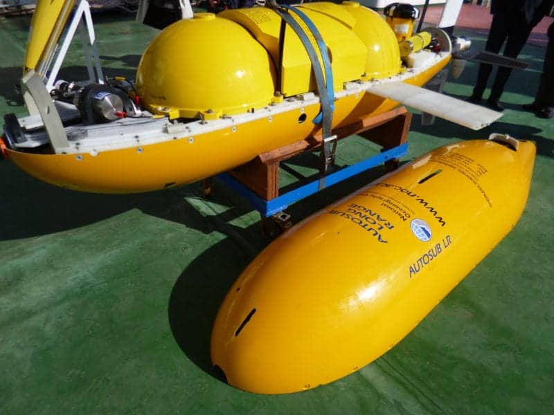
Quantcast
Channel: UUV News | Autonomous & Unmanned Underwater Vehicles | ROV News
Viewing all 689 articles
Browse latest View live

ECA Group Develops Unmanned Mine Countermeasure Simulator

$
0
0

ECA Group Minehunter drone

ECA Group has announced that its Naval Simulation teams have developed a functional simulator dedicated to Mine Countermeasure (MCM) operations. This simulator integrates the characteristics of subsea drones developed by ECA Group, as well as the knowledge gleaned from operational use of these drones over the last 30 years.

The aim of the UMS (Unmanned MCM Systems) simulator is to compare task performances, such as mine clearance duration or percentage of clearance, between different MCM systems. The UMS simulator is capable of comparing the performances of different MCM systems in a variety of modes of operation, such as amphibious assault, harbor protection, and covert operations.

By using the simulator for their own needs, ECA Group teams can orient the development of their UMIS (Unmanned MCM Information System) towards improving the collective efficiency of teams of drones.

By integrating the UMS Simulator into UMIS, ECA Group can provide a customer with an efficient tool for planning MCM operations, with the capability to choose the right set of drones for a mission and to quickly adjust the mission based on real-world conditions in the mission area such as weather and current.

The ECA Group UMS simulator was developed by the Naval Simulation teams using their experience of tactical simulators and submarine simulators.

Find suppliers of Simulators & Simulation Software >

The post ECA Group Develops Unmanned Mine Countermeasure Simulator appeared first on Unmanned Systems Technology.


Thales Launches Pathmaster Unmanned Mine Countermeasures System

$
0
0

Thales Pathmaster minehunting system

Thales has announced that it is launching Pathmaster, a fully configurable unmanned mine countermeasures system for naval forces seeking to minimise the risk exposure of their crews, at Euronaval 2016. Pathmaster draws on the latest imaging technologies and Thales claims that it is the most advanced unmanned mine countermeasures system in the world. It can be deployed from the shore, from a mine countermeasures vessel or from any other type of naval platform.

Pathmaster is flexible enough to adapt to the operational requirements of newly emerging naval powers as well as major navies. It is built around a system for reliable detection, classification and location of even the most modern mines and its fully configurable system can be tailored to the needs of individual navies.

Pathmaster is equipped with SAMDIS, Thales’s latest-generation high-resolution synthetic aperture sonar. With its multi-aspect functionality, the SAMDIS sonar views targets from three different angles. The technology has previously been successfully evaluated by the French defence procurement agency (DGA).

Thales is already using multi-aspect technology on the French-UK maritime mine countermeasures programme (MMCM). This contract was awarded in 2015 to meet specific requirements set out by France and the United Kingdom. SAMDIS technology has also been selected for two export programmes in Asia.

“Thales has a huge amount of expertise and experience in mine countermeasures and its systems are in service with more than half of the worldwide fleet of minehunting vessels. With the autonomous Pathmaster system, all naval forces can acquire a key capability for protecting their countries’ maritime approaches,” said Pierre-Eric Pommellet, SVP Defence Mission Systems at Thales.

The post Thales Launches Pathmaster Unmanned Mine Countermeasures System appeared first on Unmanned Systems Technology.

Saab Acquires Mine Disposal Systems Manufacturer Nordic Defence Industries

$
0
0

Saab Unmanned Underwater Vehicle

Saab has announced that it has acquired the Danish naval company Nordic Defence Industries (NDI). NDI designs and manufactures mine disposal charge systems for the naval defence industry.

“With the acquisition we are strengthening our position in the Mine Counter Measures market, building a foundation for continued profitable growth. Our regional footprint will be strengthened as well as our role as a global supplier of Mine Counter Measure solutions,” says Görgen Johansson, head of business area Dynamics.

“With the high tech solutions for mine disposal provided by NDI we will have a product portfolio that covers the total need among our Mine Counter Measure customers.”

One of NDI’s products is DAMDIC, a mine disposal charge, carried to the mine by a remotely operated vehicle such as Saab’s Double Eagle, which is already used by many navies for Mine Counter Measures operations.

The company will be integrated into Saab’s business area Dynamics within its Underwater Systems business unit. The combination of Saab’s experience and knowledge from the AUV/ROV (Autonomous Underwater Vehicle/Remotely Operated Vehicle) market and NDI’s innovative mine disposal solutions will create a unique MCM house within Saab.

“After more than 20 successful years in the defence industry, with the challenges inherent from being a small stand-alone defence company, I am pleased to see new and exciting possibilities arise for NDI from the upcoming integration with Saab,” says Jess Otzen, owner and Managing Director of NDI.

Under new management, NDI’s main office and workshops, along with its experienced and dedicated staff, will remain in Aalborg, Denmark.

The post Saab Acquires Mine Disposal Systems Manufacturer Nordic Defence Industries appeared first on Unmanned Systems Technology.

Marine Imaging Technologies ROV Captures Images of USS Arizona

$
0
0

Marine Imaging Technologies ROV

Marine Imaging Technologies (MITech), a developer of underwater optical imaging platforms, has announced that its latest remotely operated vehicle (ROV), the 11th Hour, was able to obtain never-before-seen images of the lower decks of the USS Arizona. The Arizona was a U.S. battleship destroyed in the 1941 Japanese attack on Pearl Harbor.

Working in partnership with the National Parks Service (NPS) Submerged Resources Center, WWII Valor in the Pacific National Monument and the Advanced Imaging and Visualization Laboratory (AIVL) at Woods Hole Oceanographic Institution, the project assisted the NPS in understanding the interior condition of Arizona and uncovered numerous artifacts that tell the story of the men who served aboard the ship when it was attacked on December 7, 1941. These images were shared with several remaining survivors of USS Arizona and will be broadcast in the PBS documentary “Pearl Harbor – Into the Arizona.”

“The honor and privilege of developing technology to explore heretofore unseen areas of USS Arizona on this important anniversary leaves us all speechless,” said Evan J. Kovacs, founder and CEO of MITech and developer of the 11th Hour. “This project was a challenge for all involved, but the payoff was the opportunity to give something back – in the form of these poignant images – to the remaining brave men who survived this devastating attack three-quarters of a century ago.”

The images were revealed to USS Arizona survivors, NPS scientists and managers, and government officials during and after the ROV survey of the USS Arizona in Pearl Harbor. The imagery will also assist the NPS in its efforts to manage this sunken heritage site.

“When the National Park Service had a need for a custom, full featured ROV capable of inventorying, imaging, and sampling inside the WWII battleship USS Arizona, we turned to MITech and the Advanced Imaging and Visualization Laboratory at WHOI,” said Brett Seymour, deputy chief of the NPS Submerged Resources Center. “For years MITech has been supporting NPS underwater operations with innovative and custom platforms for imaging and managing underwater resources. In the case of USS Arizona, AIVL provided full 4K imaging systems to record in the low light interior condition of the ship. MITech supplied the inspection vehicle small enough to access tight hatches and narrow hallways on multiple deck levels. It also had the ability to spool a tether/fiber umbilical to prevent entanglement, and the capacity to collect samples of unknown microbiological samples that may have a direct correlation to the long-term preservation of the ship.”

Out of respect for the nearly 1000 men still entombed in the ship and the danger to divers, the NPS enforces a strict policy that allows no non-official diving and no penetration inside USS Arizona. The NPS also remains true to its obligation of site stewardship, and believes many of the answers to site preservation lie inside the ship. Any research on the site must be done without disturbing the sanctity of the site, and has therefore relied on remote robotic technology to visually examine the upper decks of USS Arizona.

Unlike previous technologies, the 11th Hour was equipped to provide high-resolution documentation, collect vital interior samples and reach deeper into the ship due to its self-spooling hybrid tether. The ROV can carry a 4K 3D camera system provided by AIVL, numerous scientific sensors (such as dissolved oxygen and salinity), and a mechanical sampler for water or sediment samples. This self-spooling capability allowed the 11th Hour to move more freely than other ROVs and penetrate to deeper levels of the vessel. The resulting images and sampling not only captured a glimpse of life aboard USS Arizona, but provided the NPS valuable insight into the unique biological ecosystem inside the ship.

“The growing need for close-up underwater optical inspection systems is enormous. MITech’s 11th Hour vehicle allows us to visualize objects on the sea-floor in ways that we never thought possible,” says William Lange, research specialist and director of AIVL at WHOI. “Having these ‘remote eyes’ on the seafloor and in the interiors of maritime heritage wreck sites such as USS Arizona revolutionizes the way scientists and the public can experience these previously unreachable and unexplored worlds. Remote vehicles like 11th Hour will open up new submerged undiscovered worlds for the benefit of the public while increasing our understanding and exploration of the world’s ocean.”

The post Marine Imaging Technologies ROV Captures Images of USS Arizona appeared first on Unmanned Systems Technology.

NASA JPL Researches Artificial Intelligence for Submersible Drones

$
0
0

NASA JPL submersible drones


NASA has announced that a team of researchers from its Jet Propulsion Lab (JPL) and other institutions recently visited Monterey Bay, California as part of ongoing research into developing artificial intelligence for submersible drones. In addition to benefitting our understanding of Earth’s marine environments, the team hopes this artificial intelligence will someday be used to explore the oceans believed to exist on moons like Europa. If confirmed, these oceans are thought to be some of the most likely places to host life in the outer solar system.

A fleet of six coordinated drones was used to study Monterey Bay. The fleet travelled large distances seeking out changes in temperature and salinity. To plot their routes, forecasts of these ocean features were sent to the drones from shore. The drones also sensed how the ocean actively changed around them. A major goal for the research team is to develop artificial intelligence that seamlessly integrates both kinds of data.

“Autonomous drones are important for ocean research, but today’s drones don’t make decisions on the fly,” said Steve Chien, one of the research team’s members. Chien leads the Artificial Intelligence Group at NASA’s Jet Propulsion Laboratory, Pasadena, California. “In order to study unpredictable ocean phenomena, we need to develop submersibles that can navigate and make decisions on their own, and in real-time. Doing so would help us understand our own oceans — and maybe those on other planets.”

Other research members were from Caltech in Pasadena; the Monterey Bay Aquarium Research Institute, Moss Landing, California; Woods Hole Oceanographic Institute, Woods Hole, Massachusetts; and Remote Sensing Solutions, Barnstable, Massachusetts.

If successful, this project could lead to submersibles that can plot their own course as they go, based on what they detect in the water around them. That could change how data is collected, while also developing the kind of autonomy needed for planetary exploration, said Andrew Thompson, assistant professor of environmental science and engineering at Caltech.

“Our goal is to remove the human effort from the day-to-day piloting of these robots and focus that time on analyzing the data collected,” Thompson said. “We want to give these submersibles the freedom and ability to collect useful information without putting a hand in to correct them.”

At the smallest levels, marine life exists as “biocommunities.” Nutrients in the water are needed to support plankton; small fish follow the plankton; big fish follow them. Find the nutrients, and you can follow the breadcrumb trail to other marine life.

This is easier said than done. Those nutrients are swept around by ocean currents, and can change direction suddenly. Life under the sea is constantly shifting in every direction, and at varying scales of size.

“It’s all three dimensions plus time,” Chien said about the challenges of tracking ocean features. “Phenomena like algal blooms are hundreds of kilometers across. But small things like dinoflagellate clouds are just dozens of meters across.”

It might be easy for a fish to track these features, but it’s nearly impossible for an unintelligent robot.

“Truly autonomous fleets of robots have been a holy grail in oceanography for decades,” Thompson said. “Bringing JPL’s exploration and AI experience to this problem should allow us to lay the groundwork for carrying out similar activities in more challenging regions, like Earth’s polar regions and even oceans on other planets.”

The recent field work at Monterey Bay was funded by JPL and Caltech’s Keck Institute for Space Studies (KISS). Additional research is planned in the spring of 2017.

The post NASA JPL Researches Artificial Intelligence for Submersible Drones appeared first on Unmanned Systems Technology.

ECA Group Equips French Navy AUVs with Long-Range Communications

$
0
0

French Navy AUV

ECA Group has announced that the company is to update six of the French Navy’s A9-M Autonomous Underwater Vehicles (AUVs) with new long range communication capabilities.

The A9-Ms have the ability to be deployed in any operational theater, where they capture sonar imagery to perform low level Rapid Environmental Assessments (REA) and assess the threat of mines, or conduct exploratory operations.

The vehicle can be deployed from different platforms such as ribs or larger vessels, or from land. While it is not essential to know the position of the vehicle and its status at all times, the new long range communication functions will make it possible to exchange messages with the vehicle even when beyond line of site. It will then be possible to send basic order and mission modifications, such as a return to the launch point.

ECA Group proposes to implement these functions on all of its AUVs (A9, A18, A27) , thus increasing the operational capabilities of these unmanned vehicles.

The post ECA Group Equips French Navy AUVs with Long-Range Communications appeared first on Unmanned Systems Technology.

Schmidt Ocean Institute’s New ROV Completes First Expedition

$
0
0

Schmidt Ocean Institute SuBastian ROV

The Schmidt Ocean Institute has announced that a team of geologists, chemists and biologists aboard its research vessel Falkor have just finished surveying the largely unexplored Mariana Back-Arc for life at depths greater than 13,000 feet, using a new remotely operated vehicle (ROV), SuBastian.

Dr. David Butterfield, JISAO, University of Washington, and Dr. William Chadwick, NOAA-PMEL and Oregon State University, led the group to the Back-Arc; returning for the second phase of a two-part exploration of the region. In 2015, the team of scientists located new hydrothermal vents in the Back-Arc region, including evidence of recent lava flows. This year, the team returned to these vent systems to characterize their water chemistry and biodiversity. The new results fill a gap in knowledge about the biogeography of these unique deep-sea ecosystems and has implications for how tectonic setting influences the composition of chemosynthetic animal communities worldwide.

The new vent sites have spectacular chimneys made of sulfide minerals, some up to 30 meters (100 feet) tall. The chimneys were belching smoky vent fluid at temperatures up to 365°C (690°F) and were covered with vent animals including “hairy snails,” shrimp, crabs, mussels, limpets, squat lobsters, anemones, and polychaete worms. Scientists on board Falkor suspect that some new species have been discovered at the new sites, but confirmation will have to await further study back on shore.

The new observations show that the newly discovered vent sites have an ecosystem that is characteristic of the Mariana Back-Arc, with some animal species found nowhere else on Earth. This, despite the fact that each vent site is relatively small and isolated, being separated from the others by up to 100 miles. The new observations suggest that the Back-Arc vent sites are relatively long-lived and that each site has biological “connectivity” with the others despite the long distances. The study also confirmed that the Back-Arc ecosystems are distinct and different from the nearby Volcanic Arc hydrothermal ecosystems, supporting the idea that geological and chemical environment play a key role in selecting animal community composition at hydrothermal vents.

This is the first series of scientific dives for ROV SuBastian. Equipped with numerous cameras, including a high-definition 4K video camera, the dives were live streamed onto YouTube and watched by millions. The multidisciplinary team will continue to analyze the data and samples collected during this expedition to advance research on how life thrives on these extreme deep-sea hydrothermal vents. This research was supported by the NOAA Ocean Exploration and Research Program, the NOAA Pacific Islands Regional Office, and the Schmidt Ocean Institute.

Watch a video about the expedition below:

The post Schmidt Ocean Institute’s New ROV Completes First Expedition appeared first on Unmanned Systems Technology.

US Navy Develops New UUV Mission Software Framework

$
0
0

US Navy UUV

Scientists and engineers at the U.S. Navy’s Naval Surface Warfare Center Panama City Division have announced that they have developed a way to change unmanned underwater vehicle (UUV) mission information as easily as updating an app on a cell phone.

NSWC PCD Autonomous Systems Engineers, Drs. Matthew Bays and Drew Lucas, refer to the system as “Autonomy in a Box.” The software has been designed to reduce the level of effort and lead time required to program an UUV’s mission.

“Autonomy in a Box is designed to make installing configurations of autonomy software on a vehicle as easy as installing an application from an app store,” said Bays.

The goal of Autonomy in a Box is to develop a quickly-deployable software solution to give unmanned systems a basic autonomy capability, support configuration management of an autonomy framework to facilitate easier experimentation and compartmentalize autonomy software development.

Currently, UUVs are a shared asset between many software developers and autonomy protects. When developers write access to their algorithms and operating system, it requires step by step installations before every new test, in addition to a verification process. This effort can take anywhere from days to weeks to perform and at a great cost in both dollar terms and schedule for mission execution.

Bays said Autonomy in a Box makes it significantly easier to install, deploy, reconfigure and test an autonomy solution within an unmanned system in a fraction of the time.

With Autonomy in a Box, NSWC PCD has introduced the use of Docker software pre-developed “containers” to solve this problem. The container itself is basically one large file which allows users to package an application into a standardized unit for software development. These containers condense the software into a complete file system that contains everything it needs to run.

From this, autonomy developers can develop their own Docker containers or work with provided baselines.

“Any group or program that wants to test their autonomy software can get a copy of the base frameworks within a Docker image and integrate their experimental software off-site into the image,” said Bays. “After the copy is returned, the integrity of the software would need to be verified with respect to the changes they have made and deploy it onto our unmanned assets.”

The same physical platform might be used to perform a different mission, run a different autonomy experiment, or otherwise be modified in configuration from one day to the next by different groups.

“The Autonomy in a Box system facilitates shared-asset scenarios by making it significantly easier to install and re-configure autonomy software,” said Lucas.

The Autonomy in a Box system was demonstrated using National Unmanned Systems Shared Resource Center (NUSSRC) vehicles at the Hell Bay IV Trials in Scotland as part of the United Kingdom’s Unmanned Warrior exercise.

Bays, Lucas and their team are working towards integrating Autonomy in a Box on other NUSSRC assets, developing a topside autonomy testing container, creating more advanced auto-detection features for detecting what type of vehicle the Autonomy in Box software is connected to and automatically configure itself to that vehicle.

The post US Navy Develops New UUV Mission Software Framework appeared first on Unmanned Systems Technology.


General Dynamics Announces Availability of Bluefin SandShark AUV

$
0
0

Bluefin Sandshark AUV

General Dynamics Mission Systems has announced the availability of the company’s new Bluefin SandShark autonomous underwater vehicle (AUV). Designed for defense, commercial and scientific applications, the Bluefin Sandshark weighs less than 11 pounds before adding a mission payload, fits in a backpack, can swim up to five knots and dive down to 200 meters (656 feet). The tail section of the Bluefin SandShark houses the battery and system electronics and is designed to leave most of the vehicle open for the user to customize with sensors and other mission critical payloads. The Bluefin SandShark joins the company’s Bluefin Robotics family of autonomous underwater products.

“Compared to other small AUVs, the Bluefin SandShark offers customers the most flexibility and diverse mission capabilities at a very affordable cost,” said Carlo Zaffanella, vice president and general manager of Maritime and Strategic Systems for General Dynamics Mission Systems. “Depending on how it is configured, the Bluefin SandShark AUV can provide intelligence, surveillance and reconnaissance information for defense or harbor security missions, dive down to survey submerged structures or become a floating communications network node at sea.”

The Bluefin SandShark’s operating software is compatible with most underwater vehicle autonomy suites, the software languages AUV operators use to talk to the vehicle and program its mission instructions. This operating flexibility makes integration with existing underwater vehicle components and systems faster and more cost-effective.

Changing, adding and reconfiguring the payload section can be performed quickly, without specialized tools. This capability allows Bluefin SandShark customers to efficiently and cost-effectively create and test small, low-power sensors and other capabilities needed for underwater tasks. The Bluefin SandShark payload section can be dry or free-flooded, based on the customer’s needs.

In addition to the Bluefin SandShark AUV, the vehicle’s starter kit includes:

  • 18-inch flooded payload section with nose fairing
  • 110 Volt AC shore power-charger
  • Wireless router
  • Maintenance and spares kits
  • Durable rolling case
  • Forthcoming availability of a pre-configured side-scan sonar payload

The post General Dynamics Announces Availability of Bluefin SandShark AUV appeared first on Unmanned Systems Technology.

ECA Group to Develop Ultra-Deep AUV for Survey and Inspection

$
0
0

CORAL AUV Project

The ECA Group has been selected by Ifremer to develop an ultra-deep Autonomous Underwater Vehicle (AUV), capable of reaching 6000 meters water depth. By choosing the ECA Group through an international call for tender, Ifremer is establishing the CORAL Alliance (Cooperative Off-Shore Robotics ALliance), facilitating project development with selected industrial partners.

The ECA Group will be the prime partner in the CORAL Alliance, which aims to promote innovation and competitiveness to link ocean science with the marine industry. The CORAL Alliance is funded by Ifremer, Provence-Alpes-Côte-d’Azur Region and the European Union (FEDER program). As major stakeholder, Ifremer will be driving the project with engineering and R&D efforts, technical and naval means for qualification of the new system, therefore fostering innovation and expertise on a regional, national and European level. Ifremer will oversee the development of the new AUV vehicle and its associated equipment. Furthermore, Ifremer will develop the AUV control software system in order to meet current and future needs of scientific end users.

The AUV will be able to accomplish wide coverage acoustic mapping as well as optical inspection by hovering close to the sea floor. “The system will deploy a full range of scientific sensors in modular packages, innovating in design optimization, autonomy, payload volume and navigation capabilities. The AUV will facilitate producing accurately georeferenced, wide area, high resolution and multi parameter representations of deep water marine environments” explains Jan Opderbecke, head of the Underwater Systems Unit, located at Ifremer facilities in Toulon. After a development period of three years, the AUV will accomplish its first dives in 2019.

“The association of long endurance survey and low altitude hovering capabilities will have high potential in various fields of application. For future commercialization by ECA Group of this AUV branded A6K, the system specifications are particularly interesting for missions such as deep sea mining survey, oil / gas pipeline inspections, rescue missions and mineral resource exploration”, underlines Claude Cazaoulou, Director of Sales and Business Development from ECA Group Robotics Division in Toulon.

“The new vehicle will be deployed from French and international oceanographic research vessels in missions involving other deep water intervention vehicles, starting with Ifremer’s Victor 6000 ROV and Nautile manned submersible” explains Jan Opderbecke from Ifremer. An innovative optical communication device currently under development at Ifremer as well as hovering capabilities of the new AUV will enable real time data exchange with other underwater vehicles. The implementation of combined exploration and intervention operations will enhance the innovation potential offered by this new system.

Furthermore, the following aspects will be developed during the new AUV project:

  • The compact and innovative design will be compatible with launch and recovery modes already developed by ECA Group during ESPADON project in 2016. A containerized transportsolution will simplify system mobilization, reducing operational expenditures.
  • The design will as well benefit from ECA Group experience gathered during AUV ALISTAR 3000 developments for hovering capabilities, where high performance pipeline inspections were being deployed
  • The embedded controller developed by Ifremer will be tightly coupled with the vehicle’s sensor payloads and provide online re-planning and event driven autonomous missionbehaviors. Onboard processing algorithms developed in cooperation with the scientific end–users will allow optimizing long duration missions on high level, meeting well defined scientific goals. The ability to perform targeted multi-parameter (physical and chemical properties,acoustic, optic, laser scanning imagery) data acquisition will constitute a significant performance improvement over existing autonomous platforms and will allow the scientificend user to better characterize vast areas of the seafloor.

“ECA Group and Ifremer have a strong industrial relationship built over the last 30 years” says Claude Cazaoulou, at ECA Group. “We have developed projects such as EPAULARD, the very first autonomous robotic submarine capable of taking photographs at a depth of 6000 m. More recently, ECA Group was strongly involved in developing HROV Ariane, a new hybrid technology which combines the ability to gather high resolution data in 2500 m water depth, performing vertical inspection and intervention tasks while reducing operational expenditures, through the implementation of a ROV and AUV systems in the same architecture.”

The post ECA Group to Develop Ultra-Deep AUV for Survey and Inspection appeared first on Unmanned Systems Technology.

Saab Seaeye Upgrades Falcon ROV

$
0
0

Saab Seaeye Falcon ROV


Saab Seaeye has announced that it has upgraded its Falcon underwater electric robotic vehicle. The Falcon’s smart intelligent control system has been enhanced with Saab Seaeye’s advanced iCON behaviour-based intelligent control architecture. This means that the Falcon can now host many new features, making it an advanced platform for further automation and behaviour-based software development.

Station‐keeping and fine position adjustment is an important new attribute that reduces the operator’s workload by allowing them to concentrate on the task at hand. Fitting a Doppler Velocity Log (DVL) and interface node has made this possible. It is also now possible to add higher accuracy sensors for heading, depth and altitude.

The iCON enhancement is available on all new Falcons, or as an upgrade to existing vehicles. It comes as a new design surface control console that incorporates the iCON software – already a feature of Saab Seaeye’s successful Leopard work system.

The new control console features a wide, high-resolution touchscreen monitor, customisable graphic user interface and an ability to record video and still images. It also offers user-friendly system configuration and diagnostic pages. iCON’s building block simplicity is key to the company’s ongoing success as it allows harmonious migration of technology throughout Saab Seaeye’s range and is currently accelerating new systems development.

The Falcon’s concept comes from a careful balance of five powerful thrusters and an intelligent distributed control system in a small, easily manhandled 1 x 0.5 x 0.6 metre size versatile chassis. Its power and control make it highly manoeuvrable and able to master strong crosscurrents whilst undertaking precision tasks with steadiness and precise manoeuvrability.

Introduced in 2002, the Falcon’s pioneering distributed intelligence provides each device on the vehicle with its own microprocessor, thereby allowing tools and sensors to be easily added or changed, and custom options to be integrated – making it an ideal platform for numerous intricate and demanding applications.

The Falcon range is available in 300 and 1000 metre depth ratings and can undertake a vast range of widely varying tasks across many key market sectors.

The post Saab Seaeye Upgrades Falcon ROV appeared first on Unmanned Systems Technology.

Deep Ocean Engineering Announces Phantom L6 ROV

$
0
0

Deep Ocean Engineering Phantom-L6 ROV
Deep Ocean Engineering has announced the Phantom L6, the company’s newest addition to the Phantom series of inspection-class ROVs. The applications for use of the Phantom L6 span a broad spectrum of industries, including:

Infrastructure inspections – bridges, tunnels, pipelines, ships
Hydroelectric system monitoring – power plants, dams, reservoirs
Homeland Security – law enforcement, military
Exploration – oil and gas, salvage, search and recovery

Per John Bergman, Deep Ocean Engineering, Vice President of Engineering, commented: “The Phantom L6 is our latest entry into the 500m inspection class ROV arena. It comes equipped with active roll stabilization and heading gyro stabilization, allowing the pilot to control with precision, while minimizing exhausting, repetitive movement. As with other Phantom series ROVs, we offer an open-frame architecture for easier mechanical integration, and dedicated expansion bulkhead connectors are provided as standard. Its six enhanced Tecnadyne thrusters provide sufficient power to raise the ROV out of areas that could otherwise trap a smaller ROV.”

The features of the standard Phantom L6 platform include:

  • Active roll stabilization
  • Advanced dynamic rolling maneuvers
  • 110 pounds vertical lifting force
  • Motion eliminating cleats available
  • Extreme payload capacity
  • Diverse sonar integration options
  • Five Degrees of Freedom maneuverability
  • Easy reconfiguration and customization
  • 18,000 lumens high output illumination

The post Deep Ocean Engineering Announces Phantom L6 ROV appeared first on Unmanned Systems Technology.

ECA Group Announces New 300m Rated Inspection-Class ROV

$
0
0

ECA Group H300-V ROV
ECA Group has announced the launch of the H300-V, the company’s latest Remotely Operated Vehicle (ROV). Announced at the Underwater Intervention 2017 conference, the H300-V is a new version of ECA Group’s H300 dedicated to observation and inspection missions.

The H300-V ROV has been developed to meet the demanding market requirements for observation-class ROVs in harsh environments. Portable and compact, the H300-V is equipped with 4 horizontal vectored thrusters, and can reach speeds of up to 3.5 knots.

As with all of ECA Group’s H-series ROVs, the H300-V is fitted with a B&W TV camera for navigation as well as a color zoom TV camera for inspection, with optical zoom mounted on a genuine pan & tilt unit. Equipped with auto heading and auto depth functions, the H300-V is able to record videos and data under strong currents at 300m depth.

The payload capabilities of the H300-V (up to 15kg) enables a wide scope of missions in many configurations, encompassing sonar, USBL, electric manipulator arms, altimeters with auto altitude function, and others.

Positioned in the ECA ROV range between the H300 MK2 (300m range) and the H800 (1000m range, 4.5 knots speed) vehicles, H300-V is already being used by several Navies and offshore service companies where accuracy of piloting and robustness are their main requirements.

Philippe Roumegue, Sales Director of ECA Group’s Robotics Department, commented: “There are two main reasons for this new version of the H300 ROV.The first is the need to enhance the speed performance and all-directions operating quality of the vehicle, leading us to equip this ROV with 4 vectored thrusters. The second is the growing demand for an ECA Group ROV with the same properties as the H800 ROV but specialized for shallow waters at a maximum of 300 meters depth. The great success of our ROV H800 has convinced us to develop a compact and portable 300m version.”

The post ECA Group Announces New 300m Rated Inspection-Class ROV appeared first on Unmanned Systems Technology.

National Oceanography Centre AUV Prepares for First Antarctic Mission

$
0
0

NOC Autosub Long Range AUV
A team of ocean scientists from the University of Southampton and British Antarctic Survey (BAS), alongside engineers from the National Oceanography Centre (NOC), will deploy an autonomous underwater vehicle (AUV) on an expedition to study some of the deepest and coldest abyssal ocean waters on earth – known as Antarctic Bottom Water (AABW) – and how they affect climate change.

The team of researchers will assess water flow and underwater turbulence in the Orkney Passage, a region of the Southern Ocean around 3,500m deep and roughly 500 miles from the Antarctic Peninsula.

They will use one of the Autosub Long Range class of unmanned submersibles developed by the NOC, now known as Boaty McBoatface, following last year’s campaign by the Natural Environment Research Council (NERC) to name the UK’s new polar research ship.

The DynOPO (Dynamics of the Orkney Passage Outflow) expedition will travel to the Southern Ocean aboard the BAS research ship RRS James Clark Ross, departing Punta Arenas in Chile. The researchers will use a combination of specialised instruments deployed from a ship, instruments moored to the seafloor, as well as measurements made by Boaty, to measure ocean turbulence.

The submersible will travel back and forth through an abyssal current of Antarctic Bottom Water along the Orkney Passage while measuring the intensity of the turbulence. This current forms off the coast of Antarctica as cold winds off the ice sheet cool the sea surface. The resulting cold, dense water sinks and moves northwards, forming an important part of the global circulation of ocean water. The Orkney Passage is a key chokepoint that AABW has to navigate on its way from Antarctica’s Weddell Sea to the Atlantic Ocean.

Current evidence suggests that changing winds over the Southern Ocean affect the speed of seafloor currents carrying AABW. The speed of these currents determines how turbulent their flow around underwater mountain ranges (submarine topography) is. Faster flow is more turbulent, and in this turbulence more heat is mixed into AABW from shallower, warmer ocean layers – thus warming the abyssal waters on their way to the Equator, affecting global climate change.

Professor Alberto Naveira Garabato from the University of Southampton, the lead scientist of the research cruise, commented: “We know that a major driver of the abyssal ocean warming, at least in the Atlantic Ocean, is changes in winds over the Southern Ocean.

“The abyssal waters of the World Ocean sink in the Southern Ocean, and flow northward along the seafloor in submarine streams. When these streams encounter submarine topography or key chokepoints, they navigate it by squeezing through valleys and around mountains, occasionally forming submarine waterfalls – much as a river flowing toward the sea does on the Earth’s surface.

“The Orkney Passage is a key chokepoint to the flow of abyssal waters in which we expect the mechanism linking changing winds to abyssal water warming to operate. We will measure how fast the streams flow, how turbulent they are, and how they respond to changes in winds over the Southern Ocean.

“Our goal is to learn enough about these convoluted processes to represent them (for the first time) in the models that scientists use to predict how our climate will evolve over the 21st century and beyond.”

BAS oceanographer Dr Povl Abrahamsen, a co-investigator of the study, said, “We have been monitoring the flow of AABW through the Orkney Passage for years. The DynOPO project will provide us with a unique, high-resolution dataset combining moored and moving instruments, that will help us get to the bottom of the complex physical processes occurring in this important region.”

Professor Alberto Naveira Garabato added: “One of the most surprising features of the climate change that we are currently experiencing is that the abyssal waters of the world ocean have been warming steadily over the last few decades. Establishing the causes of this warming is important because the warming plays an important role in moderating the ongoing (and likely future) increases in atmospheric temperature and sea level around the globe.”

This research is funded by Natural Environment Research Council (NERC).

The post National Oceanography Centre AUV Prepares for First Antarctic Mission appeared first on Unmanned Systems Technology.

General Dynamics Successfully Completes Evaluation of Knifefish UUV

$
0
0

General Dynamics Knifefish UUV
General Dynamics Mission Systems has announced that it has successfully completed a comprehensive evaluation of Knifefish, an autonomous surface mine countermeasure (SMCM) unmanned undersea vehicle (UUV). In coordination with the U.S. Navy, the test events took place off the coast of Boston using submerged Navy mine test targets. The evaluation represents a significant milestone in the Knifefish program and demonstrates the UUV’s capability to detect and classify potential mines, at a variety of depths, each posing a unique threat to naval vessels operating in a mission area.

“The information and situational awareness Knifefish will deliver to sailors is a quantum leap in clarity and accuracy over other mine-hunting systems currently used by the Navy,” said Carlo Zaffanella, vice president and general manager of Maritime and Strategic Systems for General Dynamics Mission Systems.

Simulating mine-hunting missions, the UUV located and classified mine test targets submerged at various depths and on the seafloor. Knifefish is also capable of locating and identifying mines buried in the seafloor.

“The Navy continues to work with its industry partner, General Dynamics Mission Systems, to develop, test, and deliver the needed Knifefish capability to the fleet,” Capt. Jon Rucker, Program Manager for the Navy’s Unmanned Maritime Systems Program Office (PMS406) said. “The system performed well against a variety of surrogate targets and we are confident we will refine its performance to support the planned schedule in 2017.”

Knifefish will undergo additional at-sea testing to further refine system performance in advance of formal System Acceptance Testing with the Navy.

A U.S. Navy program, Knifefish is a heavyweight-class mine countermeasure UUV intended for deployment from Navy surface vessels. Knifefish will reduce risk to personnel by operating in the minefield as an off-board sensor while the host ship stays outside the minefield boundaries.

General Dynamics Mission Systems is the prime contractor for the Knifefish program. The company designed the tactical UUV using an open architecture concept that can be quickly and efficiently modified to accommodate a wide range of missions that may face future naval operations. The Knifefish UUV is based on the General Dynamics Bluefin Robotics Bluefin-21 deep-water AUV.

The post General Dynamics Successfully Completes Evaluation of Knifefish UUV appeared first on Unmanned Systems Technology.


WFS Technologies and Seatronics Demonstrate Drone-to-ROV Wireless Communications

$
0
0

Seatronics Predator II ROV
WFS Technologies, a developer of subsea wireless automation, and marine rental equipment specialist Seatronics Inc. have announced that the two companies have demonstrated drone-to-ROV wireless communications at a Subsea Internet of Things event in Houston.

The demonstration took place at the Delta SubSea (DSS) test tank facility in Houston, Texas and was attended by representatives from Shell, ExxonMobil, Chevron and BP.

Seatooth wireless controllers were integrated with a Seatronics Predator II Inspection Class ROV and a DJI Inspire drone. 2-way data communications between the ROV and the drone were demonstrated while the ROV was submerged in a test tank and the drone flew overhead.

“We are helping our customers to drive down costs. Using proven subsea wireless automation deployed by inspection and light class ROVs, we are delivering improved asset integrity information at a fraction of the cost,” said Brendan Hyland, Chairman of WFS. “This demonstration has opened the door to using drones to harvest sensor information from assets in shallow water.”

“Seatronics Predator II ROV has the ability to fully interface WFS wireless communication products with ease. There are many benefits in using the Predator II ROV system for this application due to its size, stability and flexibility of interfacing sensor packages over other solutions,” said Euan Mackay, Vice President , Seatronics Inc.

Watch a video of the demonstration below:

The post WFS Technologies and Seatronics Demonstrate Drone-to-ROV Wireless Communications appeared first on Unmanned Systems Technology.

Kraken KATFISH Sonar Successfully Completes Phase One Sea Trials

$
0
0

Kraken KATFISH Synthetic Aperture Sonar

Kraken Sonar has announced that it has successfully completed phase one sea trials of its KATFISH towed Synthetic Aperture Sonar system.

Karl Kenny, Kraken’s President and CEO, said: “These are exciting times in the underwater robotics industry. Customers are starting to fully understand the cost and risk mitigation benefits of unmanned systems. Both military and commercial markets are showing encouraging growth as they are now incorporating unmanned vehicles and intelligent sensors in their procurement plans and budgets. In fact, industry analysts Market Info Group estimates that the global unmanned maritime systems market will reach $2 billion by 2020.”

The goals of the initial sea trials were to validate KATFISH towing performance at various speeds and sea states; to operate and validate the system’s hydrodynamic flight sensors; and to operate onboard sonars including the AquaPix MINSAS 180 Synthetic Aperture Sonar. Other system sensors that were tested included a high accuracy Ultra Short Base Line positioning system utilizing both topside and underwater inertial navigation; and platform sensors for velocity, current, temperature and depth measurements. The manually operated KATFISH Launch and Recovery System, designed by Kraken’s Handling Systems Group based in Dartmouth, Nova Scotia, was also tested and evaluated.

To date, tow speeds up to 8 knots have been successfully demonstrated in shallow water depths up to 50 metres and in sea state conditions up to Beaufort 5 scale. In all sea states and towing conditions, the hydrodynamic stability of the KATFISH exceeded expectations.

Dr. Tom Tureaud, Kraken’s Vice President for Underwater Systems said, “We are very pleased with the positive results from the initial sea trials of KATFISH. We are confident that the KATFISH system will provide a considerable advancement in seabed survey missions for military and commercial applications.”

Phase Two testing has several operational objectives. The operational depth will be increased to 200 metres, resulting in significantly higher drag forces and a corresponding larger vertical maneuvering envelope. Operators will also be evaluating the first version of Kraken’s new SASView 3D visualization software.

At the same time, target detection performance of the first commercially available MINSAS 180 sonar will be evaluated, using known targets of opportunity for detailed resolution and range measurements. Finally, Kraken’s innovative Fault Detection and Fault Response (FDFR) system will be integrated into the KATFISH and exercised through the complete operating envelope, helping to ensure safe and efficient operations.

Upon completion of Phase Two sea trials, the KATFISH system will undergo final Factory Acceptance Testing. Shipment to the customer is planned for April 2017 followed by integration of the system onboard the customer’s Unmanned Surface Vessel.

The post Kraken KATFISH Sonar Successfully Completes Phase One Sea Trials appeared first on Unmanned Systems Technology.

Norway Selects Kongsberg’s HUGIN AUV for Mine Hunting Missions

$
0
0

Kongsberg Maritime AUV

Kongsberg Maritime has announced that it has signed a contract with the Norwegian Defence Materiel Agency (NDMA) for delivery of four complete HUGIN AUV (Autonomous Underwater Vehicle) systems for detection, classification and identification of mines.

The HUGIN AUVs will have a depth rating of 3000 meters, and will be equipped with advanced sensors for modern mine hunting. The deliveries include systems for planning, execution and analysis of missions, and launch and recovery systems both for the Navy’s mine hunting vessels, as well as in mobile containers.

“Our job is to continuously develop and modernise the Norwegian Armed Forces, and the acquisition of HUGIN is an important part of the Royal Norwegian Navy`s transition to autonomous systems for mine countermeasures, said Bård Øina, project manager at the Norwegian Defence Materiel Agency.

“We are proud that the Norwegian Defence Material Agency has chosen Kongsberg Maritime as a supplier of new AUV systems. The HUGIN systems that will be delivered to the Norwegian armed forces will contribute to more efficient and safe operations. The two mobile container systems being delivered are portable and flexible, and can therefore be used by several different vessel types. We are also to deliver training and maintenance,” commented Egil Haugsdal, President at Kongsberg Maritime.

“The Royal Norwegian Navy, the Norwegian Defence Research Establishment and KONGSBERG have worked on development and verification of AUV systems for mine hunting over many years. We look forward to continued collaboration,” added Haugsdal.

The post Norway Selects Kongsberg’s HUGIN AUV for Mine Hunting Missions appeared first on Unmanned Systems Technology.

Kraken Develops 3D Underwater Laser Imaging System for AUVs

$
0
0

Kraken Sonar Seavision Laser Imaging SystemKraken Sonar has announced that its subsidiary, Kraken Robotik GmbH, will introduce its new SeaVision system at the Ocean Business conference in Southampton, UK.

SeaVision is an RGB underwater laser imaging system that offers the resolution, range and scan rate to deliver dense full colour 3D point cloud images of subsea infrastructure with millimetre accuracy in real time. The initial system is designed for deployment on underwater robotic platforms such as Remotely Operated Vehicles (ROVs) and Autonomous Underwater Vehicles (AUVs). A hand-held diver system is planned for release in the future.

In recent years, 3D imaging sensors have increased in popularity in fields such as human-machine interaction, augmented reality, cartography and movies. These sensors provide raw 3D data that is processed by imaging software to obtain 3D volumetric information. This workflow is known as 3D reconstruction and is a tool that to date has been primarily used in terrestrial and aerospace applications.

However, the ability to generate accurate 3D reconstruction of underwater infrastructure is an important requirement for commercial, military and ocean research applications. While sonar is the technology of choice for covering large areas, 3D laser systems such as Kraken’s SeaVision provide significantly higher resolution and accuracy at inspection ranges of under 10 metres.

SeaVision uses a full colour laser scanning process that is repeated thousands of times per second to generate coordinate values of millions of points on a reflected surface. The coordinates and intensity associated with each reflected laser pulse are processed in real time to generate an ultra high resolution point cloud. SeaVision produces over 300,000 colored points per second and can reconstruct a 3D object in real-time with typical spatial accuracy of less than 2 millimetres. These datasets can be used to create highly detailed models for 3D visualization, asset management, artificial intelligence and predictive analytics.

Unlike other underwater laser scanning systems, SeaVision does not have any externally moving parts. It is integrated in a compact twin pod configuration with flexible mounting options and localized auto-calibration. This enables the system to be mounted at-sea without the need for a specialist or technical support.

Using Structure from Motion photogrammetric range imaging and correlation techniques similar to Kraken’s Synthetic Aperture Sonar technology, SeaVision’s highly sensitive colour cameras are used for motion compensation and micro-navigation. Advanced signal processing algorithms correct vehicle motion during laser scanning without the need for an expensive inertial navigation system. The laser scans are co-registered to the camera images to provide both optical data and 3D point clouds for quantitative measurements.

Another unique feature is the application of six laser lines in Red, Green and Blue (RGB) colours to reproduce full colour information. All data is processed on-board in real-time and can be directly streamed and viewed topside or stored on the system’s multi-terabyte solid state drive.

SeaVision can also be used in profiling mode, where the lasers automatically maintain optimal scan angles and acquire colour 3D data as the ROV or AUV platform moves along the target.

Dr. Jakob Schwendner, Managing Director of Kraken Robotik GmbH, said, “3D laser scanning unlocks the potential of underwater surveys for subsea asset assessment. SeaVision enables the existing conditions of underwater assets to be captured as millions of data points, which can then be imported into 3D modeling software for creating realistic, to-scale images of the asset. The data available in 3D models can help improve decisions. During meetings and evaluations, 3D models will benefit both technical and non-technical people because they can easily interpret the model. The level of detail provides more useful information that helps in easy visualization and advanced analysis.”

Karl Kenny, Kraken’s President and CEO, said, “SeaVision is a very innovative and cool product. Our scientists and engineers have done a great job on its development. The combination of SeaVision with our sonar and underwater robotics technology will become a valuable tool for subsea asset management. We expect it will enable autonomous, real-time, millimetre resolution 3D modeling, change detection and predictive structural integrity assessment. It has an industry changing price and performance value proposition that will deliver improved safety, higher operating efficiencies and reduced costs for commercial, military and ocean science applications.”

Find suppliers of Cameras & Imaging Systems >

The post Kraken Develops 3D Underwater Laser Imaging System for AUVs appeared first on Unmanned Systems Technology.

Riptide Autonomous Solutions Unveils New Unmanned Underwater Vehicles

$
0
0

Riptide Autonomous Solutions UUVs
Riptide Autonomous Solutions, a developer of unmanned undersea vehicles (UUVs), has announced two new platform offerings to complement their initial micro-UUV launched in 2016.

The new 1-Man and 2-Man Portable UUVs use the same architecture, proven hydrodynamic hull shape, and high efficiency electronics as the original micro-UUV. Drawing upon advanced manufacturing techniques, modern electronics, and open source software, the larger Riptide vehicles will deliver the same flexible solution. The 1-Man Portable UUV offers a 7.5 inch (19 cm) diameter and base weight just over 60 pounds (27 kg) with a depth rating of 300 meters. The 2-Man Portable UUV has a 9.375 inch (24 cm) diameter and a base weight of roughly 120 pounds (55 kg) with a depth of 600 meters.

”We are pleased to expand our offerings and deliver even greater capabilities… Our new family of low logistics vehicles offer our users extensive flexibility for greater energy and payload volume while leveraging the proven benefits of the micro-UUV design,” commented Mr. Jeff Smith, President of Riptide.

Riptide will be exhibiting at both the Ocean Business (Southampton UK) and Sea Air Space (Washington DC) conventions.

Find suppliers of unmanned undersea vehicles (UUVs), AUVs and ROVs >

The post Riptide Autonomous Solutions Unveils New Unmanned Underwater Vehicles appeared first on Unmanned Systems Technology.

Viewing all 689 articles
Browse latest View live


<script src="https://jsc.adskeeper.com/r/s/rssing.com.1596347.js" async> </script>